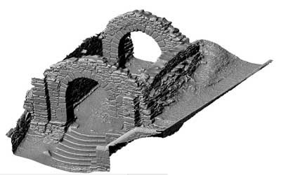
The Gateway, Glendalough (3D Model)
Remains of a formerly two-storied gatehouse situated at the NE angle of the modern enclosure. It consists of a square building (c. 4.9m x 5m internally) with round granite arches and antae in the north and south walls. Some of the paving of the causeway through the gatehouse is still intact and the ground slopes markedly upwards towards the interior of the enclosure. Each archway, however, is 3m in height from the ground to the soffit. A second floor is indicated by the presence of corbels in the interior. A possible section of the enclosure wall adjoins the NE corner. There is a slab of mica schist (dims. 2.3m x 1.5m) on the W wall with an incised Latin cross. (Leask 1950, 30-32; Barrow 1992, 28-30)
See linked document with plan taken from Robert Cochrane Historical and Descriptive Notes with Ground Plans, Elevations, Sections and Details of the Ecclesiastical Remains at Glendalough, Co. Wicklow.
SMR No.: WI023-008001-
|
Metadata
|
Information
|
|
Source
|
The Discovery Programme |
|
Contacts
|
Mr Anthony Corns
Technology Manager
The Discovery Programme
63
Merrion Square
Dublin
D2
Dublin
Dublin
Ireland
+353 1 639 3039
+353 1 639 3710
info@discoveryprogramme.ie
The Discovery Programme
|
|
Copyright Credit Line
|
Copyright © The Discovery Programme |
|
Europeana Rights
|
Creative Commons - Attribution, Non-Commercial, No Derivatives (BY-NC-ND) |
|
Spatial
|
The Gateway, Glendalough
|
|
Protection Type
|
National Monuments in State Care |
|
Start Date
|
400 |
|
End Date
|
800 |
|
Period Name
|
Early Medieval |
|
Materials
|
Stone |
|
Heritage Asset Type
|
Gateway |
|
Metadata
|
Information
|
|
Thumbnail
|

|
|
Name
|
Untextured 3D model of The Gateway, Glendalough |
|
Description
|
Untextured 3D model of the Gateway, Glendalough, Ireland |
|
Type
|
3D |
|
Format
|
x3d |
|
Extent
|
11.77mb |
|
Copyrights
|
Copyright ©The Discovery Programme
Creative Commons - Attribution, Non-Commercial, No Derivatives (BY-NC-ND)
|
|
Link
|
 |
|
Landing Page
|
 |
|
Metadata
|
Information
|
|
Name
|
Phase-based Terrestrial Laser Scanning of Glendalough |
|
Description
|
Phase based terrestrial laser scanning using a Faro Focus 120 laser scanner.
The instrument quotes the following specification: Distance accuracy up to ±2mm. Range from 0.6m up to 120m. Measurement rate up to 976,000 points/sec. Intensity & RGB. Integrated colour camera. Photorealistic 3D colour scans with up to 70 megapixels. Parallax-free colour overlay. |
|
Purpose
|
Measured survey |
|
Techinques
|
Georeferenced using RTK GPS with VRSnow corrections,Phased based terrestrial laser scanning |
|
Equipment
|
Faro Focus 3D 120,Trimble 5800 RTK GPS |
|
Actor
|
Anthony Corns, Individual, Technology Manager |
|
Actor
|
Patrick Griffin, Individual, 3D Modeller |
|
Actor
|
Robert Shaw, Individual, Senior Geo-surveyor |
|
Actor
|
Gary Devlin, Individual, Geo-surveyor |