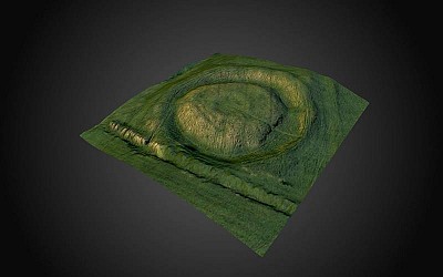
Ráith Gráinne, Tara (3D Model photo texture)
Ráith Gráinne is named after the legendary princess Gráinne, who fled from Tara and from Finn mac Cumaill with her lover Diarmait úa Duibne. It is a barrow (about 60m in diameter) consisting of a central mound surrounded by a ditch and external bank. In the centre are the remains of what may be another, small barrow. By combining geophysical and topographic data it has been possible to demonstrate that the slight prominence in the north-eastern side is actually the central burial mound of an earlier ring-barrow that was incorporated into Ráith Gráinne. It too encompasses a small barrow into its north-eastern quadrant suggesting that this was an accepted custom at the time.
To the northeast of Ráith Gráinne are the remains of up to four extremely low-profile sites which can be seen when the sun is low on the western horizon.
SMR No: ME031-033041-
|
Metadata
|
Information
|
|
Source
|
The Discovery Programme |
|
Contacts
|
Mr Anthony Corns
Technology Manager
The Discovery Programme
63
Merrion Square
Dublin
D2
Dublin
Dublin
Ireland
+353 1 639 3039
+353 1 639 3710
info@discoveryprogramme.ie
The Discovery Programme
|
|
Copyright Credit Line
|
Copyright ©The Discovery Programme |
|
Europeana Rights
|
Creative Commons - Attribution, Non-Commercial, ShareAlike (BY-NC-SA) |
|
Spatial
|
Ráith Gráinne, Tara
Castletown Tara
County Meath
Ireland
|
|
Protection Type
|
National Monuments in State Care |
|
Start Date
|
Uncertain |
|
End Date
|
Uncertain |
|
Period Name
|
Uncertain |
|
Materials
|
Earth |
|
Heritage Asset Type
|
Barrow - ring-barrow |
|
Metadata
|
Information
|
|
Thumbnail
|
|
|
Name
|
Lidar generated 3D model of Ráith Gráinne, Tara (photo texture) |
|
Description
|
Lidar generated 3D model of Ráith Gráinne, Tara (photo texture) |
|
Type
|
3D |
|
Format
|
webGL |
|
Copyrights
|
Copyright © The Discovery Programme
Creative Commons - Attribution, Non-Commercial, No Derivatives (BY-NC-ND)
|
|
Link
|
 |
|
Landing Page
|
 |
|
Metadata
|
Information
|
|
Name
|
FLI-Map 400 Lidar Survey of the Hill of Tara |
|
Description
|
FLI-MAP 400; an aerial LiDAR survey system, was initially designed to survey infrastructural assets such as roads, railways and electricity supply networks. The sensor system mounted beneath the main helicopter fuselage consists of:
Three 150 kHz LiDAR sensors (7◦ forward, nadir and 7◦ aft);
Scanning angle 60◦
Accuracy (relative) Horizontal 5 cm, Vertical 3 cm
Multiple returns 4
Two RTK GPS receivers – provide accurate location in used in conjunction with RTK base stations;
Inertial Navigation System (INS)- continuously track the position, orientation, and velocity of the helicopter;
Digital imaging (11 megapixel) and digital video capture.
Resulting data sets include first return (DSM) and last return point (DTM, basre earth) models
|
|
Purpose
|
Remote Sensing |
|
Techinques
|
Lidar survey |
|
Equipment
|
FLI-MAP 400 Lidar system |
|
Actor
|
BKS Fugro, Organisation, Data Capture |
