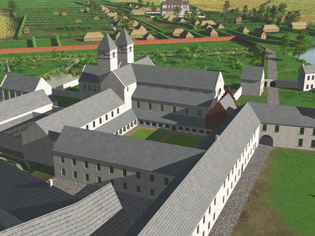
Saint Salvator abbey of Ename around 1500 (high res 3D)
Due to the pollution of the river Scheldt, originating from textile and leather production in Oudenaarde, the abbey is extending substantially the ponds around the abbey to raise fish. A 3 m high wall is separating the abbey terrain from the village.
|
Metadata
|
Information
|
|
Source
|
Visual Dimension bvba |
|
Contacts
|
Daniel Pletinckx
digital heritage expert
Visual Dimension bvba
47
Lijnwaadmarkt
Oudenaarde
9700
Ename
East Flanders
Belgium
+32 55 30 31 00
+32 55 30 31 04
daniel.pletinckx@visualdimension.be
director Visual Dimension bvba
|
|
Copyright Credit Line
|
Visual Dimension bvba, 2014 |
|
Europeana Rights
|
Creative Commons - Attribution, Non-Commercial, ShareAlike (BY-NC-SA) |
|
Spatial
|
Ename archaeological site
Archeologisch park Ename
Sint-Salvatorstraat
Oudenaarde
9700
Ename
East Flanders
Belgium
|
|
Protection Type
|
monument |
|
Start Date
|
995 |
|
End Date
|
2015 |
|
Period Name
|
medieval |
|
Materials
|
limestone, brick |
|
Heritage Asset Type
|
archaeological park |
|
Metadata
|
Information
|
|
Thumbnail
|

|
|
Name
|
Saint Salvator abbey of Ename around 1500 (high res 3D) |
|
Description
|
Due to the pollution of the river Scheldt, originating from textile and leather production in Oudenaarde, the abbey is extending substantially the ponds around the abbey to raise fish. A 3 m high wall is separating the abbey terrain from the village. |
|
Type
|
3D |
|
Format
|
Blender |
|
Actor
|
Visual Dimension bvba, organisation, creator |
|
Copyrights
|
Visual Dimension bvba, 2015
Creative Commons - Attribution, Non-Commercial, ShareAlike (BY-NC-SA)
|
|
Link
|
 |
|
Landing Page
|
 |
|
Metadata
|
Information
|
|
Name
|
virtual reconstruction of Ename |
|
Description
|
Based on |
|
Purpose
|
Interpret, understand and visualise the evolution through time of Ename |
|
Actor
|
Visual Dimension bvba, organisation, creator |