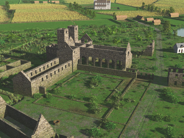
Saint Salvator abbey of Ename around 1595 (high res 3D)
The occupation of Oudenaarde by protestants of the city of Ghent in the period 1578-1582 is disastrous for the Ename abbey. The abbey is pillaged completely and most buildings are taken down to reinforce the walls of the city of Oudenaarde.
|
Metadata
|
Information
|
|
Source
|
Visual Dimension bvba |
|
Contacts
|
Daniel Pletinckx
digital heritage expert
Visual Dimension bvba
47
Lijnwaadmarkt
Oudenaarde
9700
Ename
East Flanders
Belgium
+32 55 30 31 00
+32 55 30 31 04
daniel.pletinckx@visualdimension.be
director Visual Dimension bvba
|
|
Copyright Credit Line
|
Visual Dimension bvba, 2014 |
|
Europeana Rights
|
Creative Commons - Attribution, Non-Commercial, ShareAlike (BY-NC-SA) |
|
Spatial
|
Ename archaeological site
Archeologisch park Ename
Sint-Salvatorstraat
Oudenaarde
9700
Ename
East Flanders
Belgium
|
|
Protection Type
|
monument |
|
Start Date
|
995 |
|
End Date
|
2015 |
|
Period Name
|
medieval |
|
Materials
|
limestone, brick |
|
Heritage Asset Type
|
archaeological park |
|
Metadata
|
Information
|
|
Thumbnail
|

|
|
Name
|
Saint Salvator abbey of Ename around 1595 (high res 3D) |
|
Description
|
The occupation of Oudenaarde by protestants of the city of Ghent in the period 1578-1582 is disastrous for the Ename abbey. The abbey is pillaged completely and most buildings are taken down to reinforce the walls of the city of Oudenaarde. |
|
Type
|
3D |
|
Format
|
Blender |
|
Actor
|
Visual Dimension bvba, organisation, creator |
|
Copyrights
|
Visual Dimension bvba, 2015
Creative Commons - Attribution, Non-Commercial, ShareAlike (BY-NC-SA)
|
|
Link
|
 |
|
Landing Page
|
 |
|
Metadata
|
Information
|
|
Name
|
virtual reconstruction of Ename |
|
Description
|
Based on |
|
Purpose
|
Interpret, understand and visualise the evolution through time of Ename |
|
Actor
|
Visual Dimension bvba, organisation, creator |