Ráith Lóegaire, Tara (3D Mode hillshade texture)
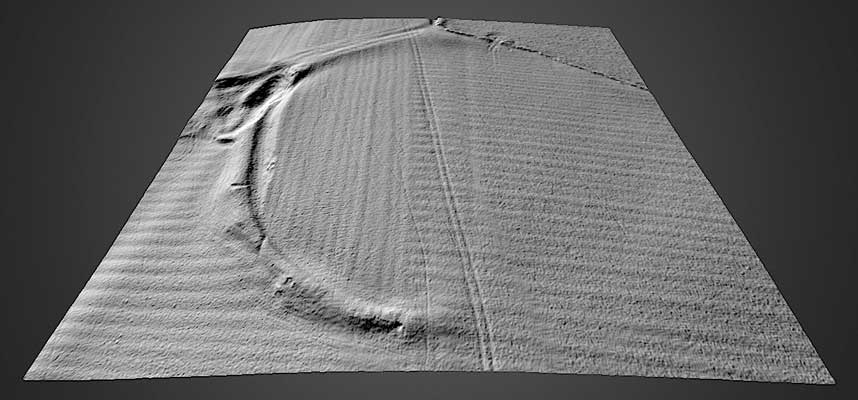
Ráith Lóegaire commemorates in its name the early historic king of Tara, Lóegaire mac Néill, famous for his reputed clash With Patrick overthe Paschal fire. Lóegaire is said to have been buried in the ramparts of Tara, facing his enemies, the Leinstermen. The monument, a circular enclosure about 150m in diameter, is one of the more problematical sites at Tara. The eastern half of the site has been erased by cultivation, but on the West side it is defined by a bank and internal ditch. There are, however, slight traces of an internal bank which, if original, suggest that the monument may have defensive characteristics. Geophysical survey has identified an entrance facing due east.
SMR No.: ME031-033001-
|
Metadata
|
Information
|
|
Source
|
The Discovery Programme |
|
Contacts
|
Mr Anthony Corns
Technology Manager
The Discovery Programme
63
Merrion Square
Dublin
D2
Dublin
Dublin
Ireland
+353 1 639 3039
+353 1 639 3710
info@discoveryprogramme.ie
The Discovery Programme
|
|
Copyright Credit Line
|
Copyright ©The Discovery Programme |
|
Europeana Rights
|
Creative Commons - Attribution, Non-Commercial, No Derivatives (BY-NC-ND) |
|
Spatial
|
Ráith Lóegaire, Tara
Castelboy
County Meath
Ireland
|
|
Protection Type
|
National Monuments in State Care |
|
Start Date
|
Uncertain |
|
End Date
|
Uncertain |
|
Period Name
|
Uncertain |
|
Materials
|
Earth |
|
Heritage Asset Type
|
Hilltop enclosure |
|
Metadata
|
Information
|
|
Thumbnail
|

|
|
Name
|
Lidar generated 3D model of Ráith Lóegaire, Tara (hill shade texture) |
|
Description
|
Lidar generated 3D model of Ráith Lóegaire, Tara (hill shade texture) |
|
Type
|
3D |
|
Format
|
webGL |
|
Copyrights
|
Copyright © The Discovery Programme
Creative Commons - Attribution, Non-Commercial, No Derivatives (BY-NC-ND)
|
|
Link
|
 |
|
Landing Page
|
 |
|
Metadata
|
Information
|
|
Name
|
FLI-Map 400 Lidar Survey of the Hill of Tara |
|
Description
|
FLI-MAP 400; an aerial LiDAR survey system, was initially designed to survey infrastructural assets such as roads, railways and electricity supply networks. The sensor system mounted beneath the main helicopter fuselage consists of:
Three 150 kHz LiDAR sensors (7◦ forward, nadir and 7◦ aft);
Scanning angle 60◦
Accuracy (relative) Horizontal 5 cm, Vertical 3 cm
Multiple returns 4
Two RTK GPS receivers – provide accurate location in used in conjunction with RTK base stations;
Inertial Navigation System (INS)- continuously track the position, orientation, and velocity of the helicopter;
Digital imaging (11 megapixel) and digital video capture.
Resulting data sets include first return (DSM) and last return point (DTM, basre earth) models
|
|
Purpose
|
Remote Sensing |
|
Techinques
|
Lidar survey |
|
Equipment
|
FLI-MAP 400 Lidar system |
|
Actor
|
BKS Fugro, Organisation, Data Capture |