Image of the Tombs of the Kings archaeological site, surveying
|
|
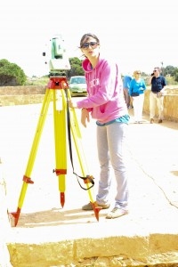
This picture depicts a member of the STARC team surveying the archaeological site of Tombs of the Kings in Paphos. During the survey of the site the team had to adopt a common system of measurements, thus, a reference survey network was created. Before the scanning process and photo acquisition targets were positioned on several visual faces of Tomb 4 as well as the surrounding area in order to reference and geo-reference the results on a local system. The image was taken during the 3D scanning session of March 2014.
| Metadata | Information |
| Source | The Cyprus Institute - STARC |
| Europeana Rights |
|
| Heritage Asset Type | Archaeological site |
| Metadata | Information |
| Thumbnail |

|
| Name | Tombs of the Kings archaeological site, surveying |
| Description | This picture depicts a member of the STARC team surveying the archaeological site of Tombs of the Kings in Paphos. During the survey of the site the team had to adopt a common system of measurements, thus, a reference survey network was created. Before the scanning process and photo acquisition targets were positioned on several visual faces of Tomb 4 as well as the surrounding area in order to reference and geo-reference the results on a local system. The image was taken during the 3D scanning session of March 2014. |
| Type | Image |
| Link |
 |
| Landing Page |
|
| Metadata | Information |
| Name | Photographic campaign, the Tombs of the Kings |
| Description | Photographic campaign for the documentation of the Tombs of the Kings archaeological site in Paphos. |
| Techinques | Photography |