Dowth Complex, Co. Meath (Turntable Movie)
|
|
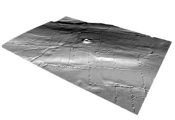
Dowth is the least well known of the three great tombs of Brú Na Bóinne although it compares in size with Knowth and Newgrange. The mound is surrounded by a kerb of 115 stones and has two tombs facing westwards. The smaller south tomb has a short passage and a circular chamber with a recess; the north tomb is cruciform in plan containing a large stone basin. There are smaller satellite tombs to the east and south-west of the large mound.
The large crater in the centre of the mound is the result of excavations in the 1840’s. There has also been quarrying of the western side. There are few surviving finds from this work but it is known that quantities of human and animal bone were found in the chambers. Like Knowth, Dowth appears to have been a focus of activity in the first millennium AD. One of the passages connects with an Early Christian souterrain or underground passage.
| Metadata | Information |
| Source | The Discovery Programme |
| Contacts |
|
| Copyright Credit Line |
|
| Europeana Rights |
|
| Spatial |
|
| Protection Type |
|
| Start Date | -4000 |
| End Date | -2500 |
| Period Name | Neolithic Period |
| Heritage Asset Type | Megalithic tomb - passage tomb |
| Metadata | Information |
| Thumbnail |

|
| Name | Turntable video of Dowth Complex Lidar, Co. Meath |
| Description | Turntable video of Dowth Complex Lidar, Co. Meath |
| Type | Movie |
| Format | mov |
| Copyrights |
|
| Link |
|
| Landing Page |
|
| Metadata | Information |
| Name | Fixed wing Lidar Survey |
| Description | The ALTM 3100 instrument is mounted on a fixed wing platform leased 365 days per year by the Agency as it forms the core mapping work undertaken. This system will be used for the proposed contract. LIDAR data will be collected at an altitude of approximately 900m, which with a scan angle of +/- 20º will result in a swath of 750m. LIDAR data will be collected at a density of approximately 1m resolution or one point per square metre. All GPS ground data is collected and processed using the in-house developed and quality assured procedures EASGT_019 and EASGT_020. |
| Purpose | Remote Sensing |
| Techinques | Lidar Survey |
| Equipment | Optech ALTM 3100 |