The Round Tower, Clonmacnoise (turntable movie)
OF005-020----
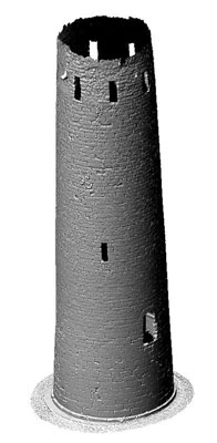
Circular tower (diam. at base 5.6m; wall T 1.12m; H 19m) five storeys high built with coursed finely cut ashlar blocks of limestone on a protruding plinth. The top storey which was rebuilt in the medieval period has 8 rectangular slits. Round headed door at first floor level, facing SE. Conical cap now destroyed, wooden floors carried on corbels at every level. One simple flat headed window at second and third floors facing SW and N respectively. Locally known as O' Rourke's tower which according to the Annals of Clonmacnoise was built in the year 1124, the roof of which was struck by lightning in 1135 (Barrow 1979, 173-5). English soldiers carried off the bell of the Round tower in 1552 (Harbison 1972, 202-4). Depicted on the first two editions of the OS 6-inch map but not on the last edition. (Cooke 1875, 372; Monahan 1886, 66-8; Westropp 1907, 290; MacAlister 1910, 20-7; O' Flanagan 1933 vol. 1, 65)
|
Metadata
|
Information
|
|
Source
|
The Discovery Programme |
|
Contacts
|
Mr Anthony Corns
Technology Manager
The Discovery Programme
63
Merrion Square
Dublin
D2
Dublin
Dublin
Ireland
+353 1 639 3039
+353 1 639 3710
info@discoveryprogramme.ie
The Discovery Programme
|
|
Copyright Credit Line
|
Copyright © The Discovery Programme |
|
Europeana Rights
|
Creative Commons - Attribution, Non-Commercial, No Derivatives (BY-NC-ND) |
|
Spatial
|
The Round Tower, Clonmacnoise
|
|
Protection Type
|
National Monuments in State Care |
|
Start Date
|
1101 |
|
End Date
|
1200 |
|
Period Name
|
12th Century AD |
|
Materials
|
Rubble, Stone |
|
Heritage Asset Type
|
Round tower |
|
Metadata
|
Information
|
|
Thumbnail
|

|
|
Name
|
Turntable video of untextured 3D model of The Round Tower, Clonmacnoise |
|
Description
|
Turntable video of untextured 3D model of The Cathedral, Clonmacnoise, Ireland |
|
Type
|
Movie |
|
Format
|
mov |
|
Copyrights
|
Copyright ©The Discovery Programme
Creative Commons - Attribution, Non-Commercial, No Derivatives (BY-NC-ND)
|
|
Link
|
 |
|
Landing Page
|
 |
|
Metadata
|
Information
|
|
Name
|
Phase-based Terrestrial Laser Scanning of Clonmacnoise |
|
Description
|
Phase based terrestrial laser scanning using a Faro Focus 120 laser scanner.
The instrument quotes the following specification: Distance accuracy up to ±2mm. Range from 0.6m up to 120m. Measurement rate up to 976,000 points/sec. Intensity & RGB. Integrated colour camera. Photorealistic 3D colour scans with up to 70 megapixels. Parallax-free colour overlay. |
|
Purpose
|
Measured survey |
|
Techinques
|
Georeferenced using RTK GPS with VRSnow corrections,Phased based terrestrial laser scanning |
|
Equipment
|
Faro Focus 3D 120,Trimble 5800 RTK GPS |
|
Actor
|
Anthony Corns, Individual, Technology Manager |
|
Actor
|
Patrick Griffin, Individual, 3D Modeller |
|
Actor
|
Gary Devlin, Individual, Geo-surveyor |
|
Actor
|
Robert Shaw, Individual, Senior Geo-surveyor |