Cell E, Skellig Michael (Sampled pointcloud model)
KE104A001037-
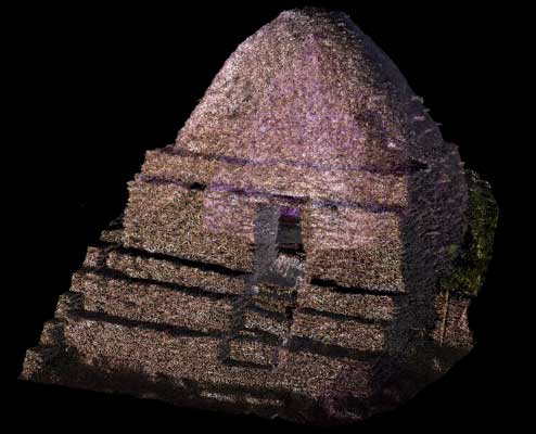
Cell E lies to the north-east of Cell D and at a higher level than the other cells. It is built of relatively small stones and has stepped plinths and projecting stones at the upper level. It is quite spacious inside, 3.65m by 3.58m, and is almost 4m high. Though almost square in plan, it becomes circular in shape as it reaches the roof. Most of its paving dates from the nineteenth century. There are some projecting stone pegs on the interior and there are holes in the walls to take wooden beams for a loft.
SKELLIG MICHAEL, CO. KERRY: THE MONASTERY AND SOUTH PEAK Archaeological stratigraphic report: excavations 1986–2010 Edward Bourke, Alan R. Hayden, Ann Lynch
|
Metadata
|
Information
|
|
Source
|
The Discovery Programme |
|
Contacts
|
Mr Anthony Corns
Technology Manager
The Discovery Programme
63
Merrion Square
Dublin
D2
Dublin
Dublin
Ireland
+353 1 639 3039
+353 1 639 3710
info@discoveryprogramme.ie
The Discovery Programme
|
|
Copyright Credit Line
|
Copyright © The Discovery Programme |
|
Europeana Rights
|
Creative Commons - Attribution, Non-Commercial, No Derivatives (BY-NC-ND) |
|
Spatial
|
Cell E, Skellig Michael
|
|
Protection Type
|
National Monuments in State Care |
|
Start Date
|
400 |
|
End Date
|
800 |
|
Period Name
|
Early Christian Period |
|
Materials
|
Stone |
|
Heritage Asset Type
|
Clochan |
|
Metadata
|
Information
|
|
Thumbnail
|

|
|
Name
|
Decimated 3D point cloud model of Cell E, Skellig Michael |
|
Description
|
Decimated 3D point cloud model of Cell E, Skellig Michael (1% of full data) |
|
Type
|
3D |
|
Format
|
webGL |
|
Extent
|
11.77mb |
|
Copyrights
|
Copyright © The Discovery Programme
Creative Commons - Attribution, Non-Commercial, No Derivatives (BY-NC-ND)
|
|
Link
|
 |
|
Landing Page
|
 |
|
Metadata
|
Information
|
|
Name
|
Phase-based Terrestrial Laser Scanning |
|
Description
|
Phase based terrestrial laser scanning using a Faro Focus 120 laser scanner.
The instrument quotes the following specification: Distance accuracy up to ±2mm. Range from 0.6m up to 120m. Measurement rate up to 976,000 points/sec. Intensity & RGB. Integrated colour camera. Photorealistic 3D colour scans with up to 70 megapixels. Parallax-free colour overlay. |
|
Purpose
|
Measured survey |
|
Techinques
|
Georeferenced using RTK GPS with VRSnow corrections,Phased based terrestrial laser scanning |
|
Equipment
|
Trimble 5800 RTK GPS,Faro Focus 3D 120 |
|
Actor
|
Gary Devlin, Individual, Geo-surveyor |
|
Actor
|
Robert Shaw, Individual, Senior Geo-surveyor |