Drombeg stone circle (Turntable Movie)
CO143-051002-
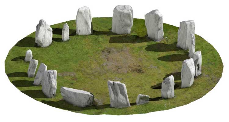
In pasture on natural rock terrace on S slope of low hill. Circle excavated 1957 (Fahy 1959, 1-27); and nearby fulacht fiadh (CO143-051002-) and hut site (CO143-051001-) in 1958 (Fahy 1960, 1-17). Circle consisted of seventeen stones; two missing and one fallen. Stones are 0.55m to 2.05m L, 0.2m to 0.65m T and 1.1m to 2.05m H. On upper surface of axial stone, largest stone in circle, are two shallow cup-marks, one surrounded by oval carving. Internal measurement along main axis, aligned NE-SW, is 9m. Five pits found within circle, sealed beneath compacted gravel floor; one pit contained deposit of cremated human bone, fragments of shale and numerous sherds of coarse fabric pot. Charcoal from burial yielded C14 determination of AD 600 ± 120 (D-62) which is 'clearly anomalous' (O Nualláin 1984a, 10). Other finds from circle included seven pieces of flint, including small convex scraper. O Nualláin 1984, 24. no. 37; Roberts 1988, Ch. 2, no. 5)
|
Metadata
|
Information
|
|
Source
|
The Discovery Programme |
|
Contacts
|
Mr Anthony Corns
Technology Manager
The Discovery Programme
63
Merrion Square
Dublin
D2
Dublin
Dublin
Ireland
+353 1 639 3039
+353 1 639 3710
info@discoveryprogramme.ie
The Discovery Programme
|
|
Copyright Credit Line
|
Copyright © The Discovery Programme |
|
Europeana Rights
|
Creative Commons - Attribution, Non-Commercial, No Derivatives (BY-NC-ND) |
|
Spatial
|
Drombeg
http://www.logainm.ie/13198.aspx
County Cork
Ireland
|
|
Protection Type
|
National Monuments in State Care |
|
Start Date
|
-4000 |
|
End Date
|
-2500 |
|
Period Name
|
Neolithic Period |
|
Materials
|
Stone |
|
Heritage Asset Type
|
Stone circle - multiple-stone |
|
Metadata
|
Information
|
|
Thumbnail
|

|
|
Name
|
Turntable movie of Drombeg Stone Circle, Co. Cork |
|
Description
|
Turntable movie of Drombeg Stone Circle, Co. Cork |
|
Type
|
Movie |
|
Format
|
mov |
|
Copyrights
|
Copyright ©The Discovery Programme
Creative Commons - Attribution, Non-Commercial, No Derivatives (BY-NC-ND)
|
|
Link
|
 |
|
Landing Page
|
 |
|
Metadata
|
Information
|
|
Name
|
Phase-based Terrestrial Laser Scanning |
|
Description
|
Phase based terrestrial laser scanning using a Faro Focus 120 laser scanner.
The instrument quotes the following specification: Distance accuracy up to ±2mm. Range from 0.6m up to 120m. Measurement rate up to 976,000 points/sec. Intensity & RGB. Integrated colour camera. Photorealistic 3D colour scans with up to 70 megapixels. Parallax-free colour overlay. |
|
Purpose
|
Measured survey |
|
Techinques
|
Georeferenced using RTK GPS with VRSnow corrections,Phased based terrestrial laser scanning |
|
Equipment
|
Trimble 5800 RTK GPS,Faro Focus 3D 120 |
|
Actor
|
Gary Devlin, Individual, Geo-surveyor |
|
Actor
|
Robert Shaw, Individual, Senior Geo-surveyor |