Monks Graveyard, Skellig Michael (3D decimated point cloud model)
KE104A001158-
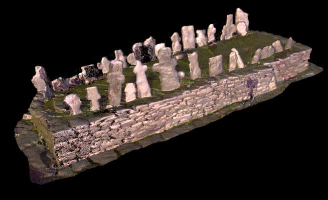
This is located to the east of the large oratory: it takes the form of a sub-rectangular platform (constructed in two phases) measuring 7.3m by 3.2m (Ill. 1.5). Its base is defined by large, long orthostats, against which a row of crosses and cross-slabs are placed vertically on the west side. The graveyard was bigger originally but the east side fell away when part of the adjacent enclosure retaining wall collapsed
SKELLIG MICHAEL, CO. KERRY: THE MONASTERY AND SOUTH PEAK Archaeological stratigraphic report: excavations 1986–2010 Edward Bourke, Alan R. Hayden, Ann Lynch
|
Metadata
|
Information
|
|
Source
|
The Discovery Programme |
|
Contacts
|
Mr Anthony Corns
Technology Manager
The Discovery Programme
63
Merrion Square
Dublin
D2
Dublin
Dublin
Ireland
+353 1 639 3039
+353 1 639 3710
info@discoveryprogramme.ie
The Discovery Programme
|
|
Copyright Credit Line
|
Copyright © The Discovery Programme |
|
Europeana Rights
|
Creative Commons - Attribution, Non-Commercial, No Derivatives (BY-NC-ND) |
|
Spatial
|
Monks Graveyard, Skellig Michael
|
|
Protection Type
|
National Monuments in State Care |
|
Start Date
|
400 |
|
End Date
|
800 |
|
Period Name
|
Early Christian Period |
|
Materials
|
Stone |
|
Heritage Asset Type
|
Leacht |
|
Metadata
|
Information
|
|
Thumbnail
|

|
|
Name
|
3D decimated pointcloud model of the Monks Graveyard, Skellig Michael |
|
Description
|
3D decimated pointcloud model of the Monks Graveyard, Skellig Michael |
|
Type
|
3D |
|
Format
|
webGL |
|
Contacts
|
Andrea D_Andrea
Coordinator
CISA
Palazzina B
8
Vico Santa Maria d_Agnone
Naples
80139
Italy
+39081293501
cisa@unior.it
|
|
Copyrights
|
Copyright © The Discovery Programme
Creative Commons - Attribution, Non-Commercial, No Derivatives (BY-NC-ND)
|
|
Link
|
 |
|
Landing Page
|
 |
|
Metadata
|
Information
|
|
Name
|
Phase-based Terrestrial Laser Scanning |
|
Description
|
Phase based terrestrial laser scanning using a Faro Focus 120 laser scanner.
The instrument quotes the following specification: Distance accuracy up to ±2mm. Range from 0.6m up to 120m. Measurement rate up to 976,000 points/sec. Intensity & RGB. Integrated colour camera. Photorealistic 3D colour scans with up to 70 megapixels. Parallax-free colour overlay. |
|
Purpose
|
Measured survey |
|
Techinques
|
Georeferenced using RTK GPS with VRSnow corrections,Phased based terrestrial laser scanning |
|
Equipment
|
Trimble 5800 RTK GPS,Faro Focus 3D 120 |
|
Actor
|
Gary Devlin, Individual, Geo-surveyor |
|
Actor
|
Robert Shaw, Individual, Senior Geo-surveyor |