St Kierans Church, Glendalough (3D Model)
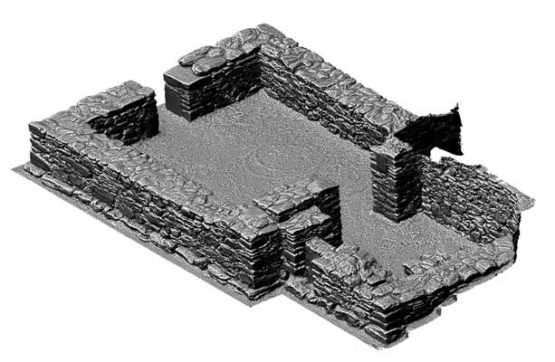
Situated SE of St Kevin's church in the NE corner of an enclosure (dims. 35m x 35m) defined by a drystone rubble wall. Foundations of a small nave (dims. c. 5.8m E-W; 4.5m N-S) and chancel (c. 2.9m E-W; 2.7m N-S) church. Features which are still evident include a W door, a narrow chancel opening, a door in the S wall of chancel, which may have led to a sacristy, and the foundations of a stone altar. The church is possibly dedicated to St Kieran, founder of Clonmacnoise, and there is a possible reference to its burning in the Annals under the year 1163. (Price 1945, 48; Leask 1950, 25-6; Barrow 1992, 39-40)
SMR No.: WI023-010----
|
Metadata
|
Information
|
|
Source
|
The Discovery Programme |
|
Contacts
|
Mr Anthony Corns
Technology Manager
The Discovery Programme
63
Merrion Square
Dublin
D2
Dublin
Dublin
Ireland
+353 1 639 3039
+353 1 639 3710
info@discoveryprogramme.ie
The Discovery Programme
|
|
Copyright Credit Line
|
Copyright © The Discovery Programme |
|
Europeana Rights
|
Creative Commons - Attribution, Non-Commercial, No Derivatives (BY-NC-ND) |
|
Spatial
|
St Kierans Church, Glendalough
|
|
Protection Type
|
National Monuments in State Care |
|
Start Date
|
400 |
|
End Date
|
800 |
|
Period Name
|
Early Christian Period |
|
Materials
|
Stone |
|
Heritage Asset Type
|
Church |
|
Metadata
|
Information
|
|
Thumbnail
|

|
|
Name
|
Untextured 3D model of St Kierans Church, Glendalough |
|
Description
|
Untextured 3D model of St Kierans Church, Glendalough, Ireland |
|
Type
|
3D |
|
Format
|
x3d |
|
Extent
|
11.77mb |
|
Copyrights
|
Copyright ©The Discovery Programme
Creative Commons - Attribution, Non-Commercial, No Derivatives (BY-NC-ND)
|
|
Link
|
 |
|
Landing Page
|
 |
|
Metadata
|
Information
|
|
Name
|
Phase-based Terrestrial Laser Scanning of Glendalough |
|
Description
|
Phase based terrestrial laser scanning using a Faro Focus 120 laser scanner.
The instrument quotes the following specification: Distance accuracy up to ±2mm. Range from 0.6m up to 120m. Measurement rate up to 976,000 points/sec. Intensity & RGB. Integrated colour camera. Photorealistic 3D colour scans with up to 70 megapixels. Parallax-free colour overlay. |
|
Purpose
|
Measured survey |
|
Techinques
|
Georeferenced using RTK GPS with VRSnow corrections,Phased based terrestrial laser scanning |
|
Equipment
|
Faro Focus 3D 120,Trimble 5800 RTK GPS |
|
Actor
|
Anthony Corns, Individual, Technology Manager |
|
Actor
|
Patrick Griffin, Individual, 3D Modeller |
|
Actor
|
Robert Shaw, Individual, Senior Geo-surveyor |
|
Actor
|
Gary Devlin, Individual, Geo-surveyor |