Bru na Boinne Landscape, Co. Meath (Images)
Brú Na Bóinne is about 8km inland from Drogheda and describes an area between the towns of Slane and Drogheda where the River Boyne meanders into a dramatic loop or bend. Brú na Bóinne – the palace or the mansion of the Boyne – is the name given to one of the world’s most important archaeological landscapes, dominated by the spectacular prehistoric passage tombs of Newgrange, Knowth and Dowth.
In recognition of the international importance of these monuments and the many other archaeological features in the area, the United Nations Educational, Scientific, and Cultural Organisation (UNESCO) has designated the Brú Na Bóinne area a World Heritage Site. Sites selected for World Heritage listing are deemed to be of outstanding universal value to humanity and are approved on the basis of their merits as the best possible examples of cultural or natural heritage.
Today at Brú Na Bóinne the remains of about forty mounds which are the oldest surviving traces of human activity in the area can be seen. They remained the focus for activity and tradition long after their formal use as burial places ended.
The passage tombs and associated monuments are in the care of the Office of Public Works
|
Metadata
|
Information
|
|
Source
|
The Discovery Programme |
|
Contacts
|
Mr Anthony Corns
Technology Manager
The Discovery Programme
63
Merrion Square
Dublin
D2
Dublin
Dublin
Ireland
+353 1 639 3039
+353 1 639 3710
info@discoveryprogramme.ie
The Discovery Programme
|
|
Copyright Credit Line
|
Copyright © The Discovery Programme |
|
Europeana Rights
|
Creative Commons - Attribution, Non-Commercial, No Derivatives (BY-NC-ND) |
|
Spatial
|
Bru na Boinne
|
|
Protection Type
|
National Monuments in State Care |
|
Start Date
|
-4000 |
|
End Date
|
-2500 |
|
Period Name
|
Neolithic Period |
|
Heritage Asset Type
|
Megalithic tomb - passage tomb |
|
Metadata
|
Information
|
|
Thumbnail
|

|
|
Name
|
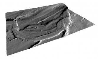
Perspective view 1 of the Brú na Bóinne landscape digital terrain model (DTM) |
|
Description
|
Perspective view 1 of the Brú na Bóinne landscape digital terrain model (DTM) |
|
Type
|
Image |
|
Format
|
image/jpeg |
|
Extent
|
11.77mb |
|
Copyrights
|
Copyright © The Discovery Programme
Creative Commons - Attribution, Non-Commercial, No Derivatives (BY-NC-ND)
|
|
Link
|
 |
|
Landing Page
|
 |
|
Metadata
|
Information
|
|
Thumbnail
|

|
|
Name
|
Perspective view 2 of the Brú na Bóinne landscape digital terrain model (DTM) |
|
Description
|
Perspective view 2 of the Brú na Bóinne landscape digital terrain model (DTM) |
|
Type
|
Image |
|
Format
|
image/jpeg |
|
Extent
|
11.77mb |
|
Copyrights
|
Copyright © The Discovery Programme
Creative Commons - Attribution, Non-Commercial, No Derivatives (BY-NC-ND)
|
|
Link
|
|
|
Landing Page
|
|
|
Metadata
|
Information
|
|
Thumbnail
|

|
|
Name
|
Perspective view 3 of the Brú na Bóinne landscape digital terrain model (DTM) |
|
Description
|
Perspective view 3 of the Brú na Bóinne landscape digital terrain model (DTM) |
|
Type
|
Image |
|
Format
|
image/jpeg |
|
Extent
|
11.77mb |
|
Copyrights
|
Copyright © The Discovery Programme
Creative Commons - Attribution, Non-Commercial, No Derivatives (BY-NC-ND)
|
|
Link
|
|
|
Landing Page
|
|
|
Metadata
|
Information
|
|
Thumbnail
|

|
|
Name
|
Perspective view 4 of the Brú na Bóinne landscape digital terrain model (DTM) |
|
Description
|
Perspective view 4 of the Brú na Bóinne landscape digital terrain model (DTM) |
|
Type
|
Image |
|
Format
|
image/jpeg |
|
Extent
|
11.77mb |
|
Copyrights
|
Copyright © The Discovery Programme
Creative Commons - Attribution, Non-Commercial, No Derivatives (BY-NC-ND)
|
|
Link
|
|
|
Landing Page
|
|
|
Metadata
|
Information
|
|
Thumbnail
|

|
|
Name
|
Plan view of the Brú na Bóinne landscape digital terrain model (DTM) |
|
Description
|
Plan view of the Brú na Bóinne landscape digital terrain model (DTM) |
|
Type
|
Image |
|
Format
|
image/jpeg |
|
Extent
|
11.77mb |
|
Copyrights
|
Copyright © The Discovery Programme
Creative Commons - Attribution, Non-Commercial, No Derivatives (BY-NC-ND)
|
|
Link
|
|
|
Landing Page
|
|
|
Metadata
|
Information
|
|
Thumbnail
|

|
|
Name
|
Vertical aerial image of the Brú na Bóinne landscape |
|
Description
|
Vertical aerial image of the Brú na Bóinne landscape |
|
Type
|
Image |
|
Format
|
image/jpeg |
|
Extent
|
11.77mb |
|
Copyrights
|
Copyright © The Discovery Programme
Creative Commons - Attribution, Non-Commercial, No Derivatives (BY-NC-ND)
|
|
Link
|
|
|
Landing Page
|
|
|
Metadata
|
Information
|
|
Name
|
Fixed wing Lidar Survey |
|
Description
|
The ALTM 3100 instrument is mounted on a fixed wing platform leased 365 days per year by the Agency as it forms the core mapping work undertaken. This system will be used for the proposed contract. LIDAR data will be collected at an altitude of approximately 900m, which with a scan angle of +/- 20º will result in a swath of 750m. LIDAR data will be collected at a density of approximately 1m resolution or one point per square metre.
All GPS ground data is collected and processed using the in-house developed and quality assured procedures EASGT_019 and EASGT_020. |
|
Purpose
|
Remote Sensing |
|
Techinques
|
Lidar Survey |
|
Equipment
|
Optech ALTM 3100 |