Passage Tomb Chamber, Newgrange (Turntable Movie)
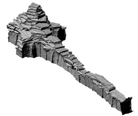
The great mound of Newgrange, 85m in max. dim. and 11m H, is delimited by a megalithic kerb. It covers a cruciform passage-tomb, 24m long, opening to SE. The chamber is roofed with a fine corbelled vault. There are two stone basins in NE recess; the others contain single basins. The 'roof box' above, some 2.4m back from the passage entrance, permits rays of the rising sun at midwinter solstice to penetrate to the chamber. Many of the kerb stones and a great number of the structural stones of the passage and chamber bear megalighic art. A circle of standing stones (ME019-045005-) surrounds the mound, and three small passage-tombs (ME019-046001-, ME019-046003--, ME019-044004-) are in close proximity to it. The monument was excavated between 1962 and 1975 (O'Kelly 1982).
|
Metadata
|
Information
|
|
Source
|
The Discovery Programme |
|
Contacts
|
Mr Anthony Corns
Technology Manager
The Discovery Programme
63
Merrion Square
Dublin
D2
Dublin
Dublin
Ireland
+353 1 639 3039
+353 1 639 3710
info@discoveryprogramme.ie
The Discovery Programme
|
|
Copyright Credit Line
|
Copyright © The Discovery Programme |
|
Europeana Rights
|
Creative Commons - Attribution, Non-Commercial, No Derivatives (BY-NC-ND) |
|
Spatial
|
Passage Tomb Chamber, Newgrange
|
|
Protection Type
|
National Monuments in State Care |
|
Start Date
|
-4000 |
|
End Date
|
-2500 |
|
Period Name
|
Neolithic Period |
|
Materials
|
Stone |
|
Heritage Asset Type
|
Megalithic tomb - passage tomb |
|
Metadata
|
Information
|
|
Thumbnail
|

|
|
Name
|
Turntable video of untextured 3D model of main chamber inside Newgrange passage tomb |
|
Description
|
Turntable video of untextured 3D model of main chamber inside Newgrange passage tomb, Bru na Boinne |
|
Type
|
Movie |
|
Format
|
mov |
|
Copyrights
|
Copyright ©The Discovery Programme
Creative Commons - Attribution, Non-Commercial, No Derivatives (BY-NC-ND)
|
|
Link
|
 |
|
Landing Page
|
 |
|
Metadata
|
Information
|
|
Name
|
Phase-based Terrestrial Laser Scanning |
|
Description
|
Phase based terrestrial laser scanning using a Faro Focus 120 laser scanner.
The instrument quotes the following specification: Distance accuracy up to ±2mm. Range from 0.6m up to 120m. Measurement rate up to 976,000 points/sec. Intensity & RGB. Integrated colour camera. Photorealistic 3D colour scans with up to 70 megapixels. Parallax-free colour overlay. |
|
Purpose
|
Measured survey |
|
Techinques
|
Georeferenced using RTK GPS with VRSnow corrections,Phased based terrestrial laser scanning |
|
Equipment
|
Trimble 5800 RTK GPS,Faro Focus 3D 120 |
|
Actor
|
Gary Devlin, Individual, Geo-surveyor |
|
Actor
|
Robert Shaw, Individual, Senior Geo-surveyor |