Temple Kelly, Clonmacnoise (High resolution 3D point cloud model)
OF005-008001-
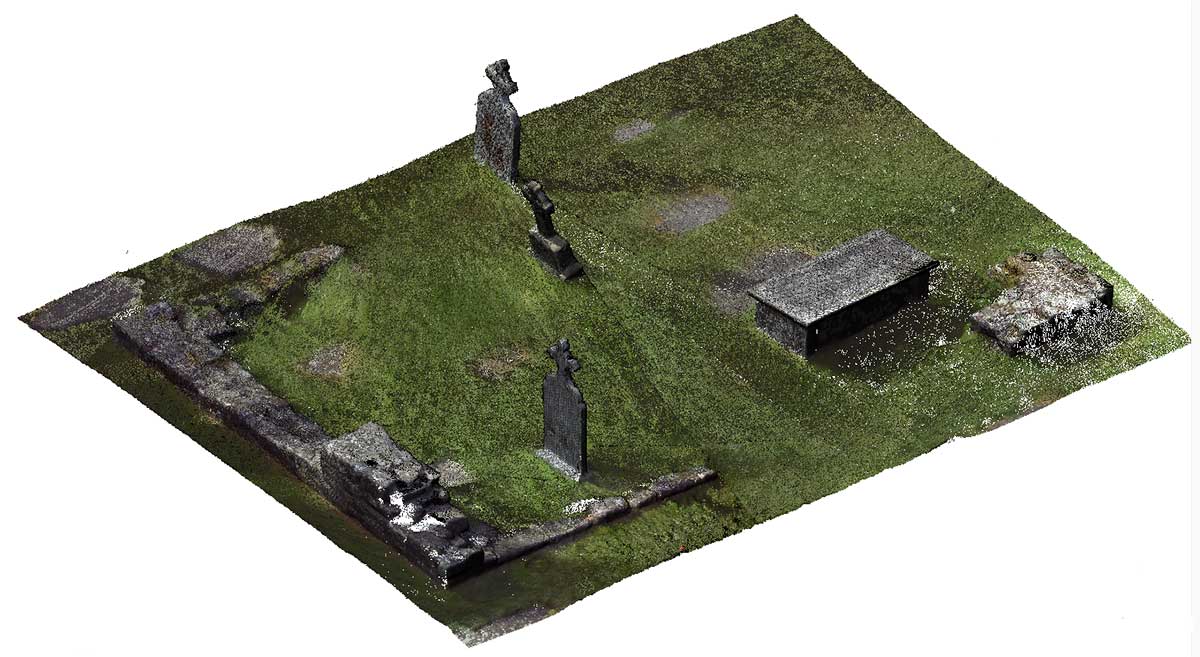
Only the partial wall foundations of a small rectangular building (6.75m N-S; 10.75m E-W; wall T 0.8m) of possible 12th-century date (Manning 1994, 26) survives with no architectural features evident. (O' Donovan 1856-7, 447; Cooke 1875, 369; Monahan 1886, 65; Anon 1907, 334; Westropp 1907; 289; Macalister 1910, 25; O'Flanagan 1933, vol. 1, 65-6; Molloy 1950, 6; Harbison 1972, 204)
|
Metadata
|
Information
|
|
Source
|
The Discovery Programme |
|
Contacts
|
Mr Anthony Corns
Technology Manager
The Discovery Programme
63
Merrion Square
Dublin
D2
Dublin
Dublin
Ireland
+353 1 639 3039
+353 1 639 3710
info@discoveryprogramme.ie
The Discovery Programme
|
|
Copyright Credit Line
|
Copyright © The Discovery Programme |
|
Europeana Rights
|
Paid access_no re_use |
|
Spatial
|
Temple Kelly, Clonmacnoise
|
|
Protection Type
|
National Monuments in State Care |
|
Start Date
|
1101 |
|
End Date
|
1200 |
|
Period Name
|
12th Century AD |
|
Materials
|
Rubble, Stone |
|
Heritage Asset Type
|
Church |
|
Metadata
|
Information
|
|
Thumbnail
|

|
|
Name
|
High resolution 3D point cloud model of Temple Kelly, Clonmacnoise |
|
Description
|
High resolution 3D point cloud model of Temple Kelly, Clonmacnoise |
|
Type
|
3D |
|
Format
|
xyz |
|
Copyrights
|
Copyright © The Discovery Programme
Paid access_no re_use
|
|
Link
|
 |
|
Landing Page
|
 |
|
Metadata
|
Information
|
|
Name
|
Phase-based Terrestrial Laser Scanning of Clonmacnoise |
|
Description
|
Phase based terrestrial laser scanning using a Faro Focus 120 laser scanner.
The instrument quotes the following specification: Distance accuracy up to ±2mm. Range from 0.6m up to 120m. Measurement rate up to 976,000 points/sec. Intensity & RGB. Integrated colour camera. Photorealistic 3D colour scans with up to 70 megapixels. Parallax-free colour overlay. |
|
Purpose
|
Measured survey |
|
Techinques
|
Georeferenced using RTK GPS with VRSnow corrections,Phased based terrestrial laser scanning |
|
Equipment
|
Faro Focus 3D 120,Trimble 5800 RTK GPS |
|
Actor
|
Anthony Corns, Individual, Technology Manager |
|
Actor
|
Patrick Griffin, Individual, 3D Modeller |
|
Actor
|
Gary Devlin, Individual, Geo-surveyor |
|
Actor
|
Robert Shaw, Individual, Senior Geo-surveyor |