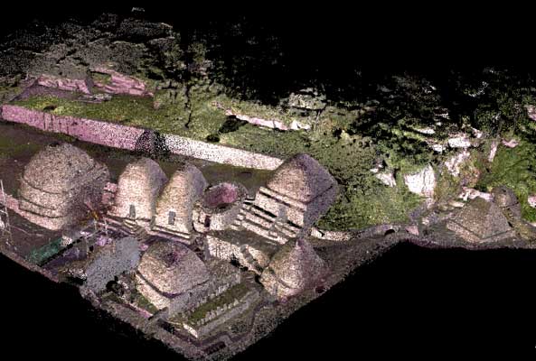
Skellig Michael Monastic Site (3D Sampled pointcloud model)
The Monastery consists of an inner stone enclosure with two oratories, a mortared church, seven cells
(five of which are intact) and the remains of a beehive toilet, water cisterns, a cemetery, leachta (possible cult shrines or pilgrim stations), crosses and
cross-slabs. It also includes two large terraces referred to as the Upper and Lower Monks’ Gardens. High
retaining walls support all the terracing, upon which everything is constructed.
|
Metadata
|
Information
|
|
Source
|
The Discovery Programme |
|
Contacts
|
Mr Anthony Corns
Technology Manager
The Discovery Programme
63
Merrion Square
Dublin
D2
Dublin
Dublin
Ireland
+353 1 639 3039
+353 1 639 3710
info@discoveryprogramme.ie
The Discovery Programme
|
|
Copyright Credit Line
|
Copyright © The Discovery Programme |
|
Europeana Rights
|
Creative Commons - Attribution, Non-Commercial, No Derivatives (BY-NC-ND) |
|
Spatial
|
Skellig Michael Island
Great Skellig
http://www.logainm.ie/22405.aspx
County Kerry
Ireland
|
|
Protection Type
|
National Monuments in State Care |
|
Start Date
|
400 |
|
End Date
|
800 |
|
Period Name
|
Early Christian Period |
|
Materials
|
Stone |
|
Heritage Asset Type
|
Monastic center |
|
Metadata
|
Information
|
|
Thumbnail
|

|
|
Name
|
3D decimated pointcloud model of Skellig Michael Monastic Site |
|
Description
|
3D decimated pointcloud model of Cell D, Skellig Michael |
|
Type
|
3D |
|
Format
|
webGL |
|
Contacts
|
Andrea D_Andrea
Coordinator
CISA
Palazzina B
8
Vico Santa Maria d_Agnone
Naples
80139
Italy
+39081293501
cisa@unior.it
|
|
Copyrights
|
Copyright © The Discovery Programme
Creative Commons - Attribution, Non-Commercial, No Derivatives (BY-NC-ND)
|
|
Link
|
 |
|
Landing Page
|
 |
|
Metadata
|
Information
|
|
Name
|
Phase-based Terrestrial Laser Scanning |
|
Description
|
Phase based terrestrial laser scanning using a Faro Focus 120 laser scanner.
The instrument quotes the following specification: Distance accuracy up to ±2mm. Range from 0.6m up to 120m. Measurement rate up to 976,000 points/sec. Intensity & RGB. Integrated colour camera. Photorealistic 3D colour scans with up to 70 megapixels. Parallax-free colour overlay. |
|
Purpose
|
Measured survey |
|
Techinques
|
Georeferenced using RTK GPS with VRSnow corrections,Phased based terrestrial laser scanning |
|
Equipment
|
Trimble 5800 RTK GPS,Faro Focus 3D 120 |
|
Actor
|
Gary Devlin, Individual, Geo-surveyor |
|
Actor
|
Robert Shaw, Individual, Senior Geo-surveyor |