Navan Fort, Co. Armagh (Images)
The enclosure is defined by a massive bank with an inner ditch, enclosing an area of c.12 acres. Within the enclosure is a much ploughed ringwork which survives mainly as a wide shallow ditch c.50m diam and a large mound 50m diam x 5m high. Excavation showed that beneath the mound had been a huge structure of concentric rings of posts which had been filled with a cairn of boulders. There were also traces of houses, rebuilt on the same spot several times. See SM7 for details of the site & excavations. Evaluations An archaeological evaluation was carried out on a site 300m SE of Navan Fort, prior to development; no archaeological features were identified [G&L, 2007]. Topsoil stripping from a site 100m W of the fort was carried out under archaeological supervision; no features of archaeological significance were noted [NAC, 2010]
|
Metadata
|
Information
|
|
Source
|
The Discovery Programme |
|
Contacts
|
Mr Anthony Corns
Technology Manager
The Discovery Programme
63
Merrion Square
Dublin
D2
Dublin
Dublin
Ireland
+353 1 639 3039
+353 1 639 3710
info@discoveryprogramme.ie
The Discovery Programme
|
|
Copyright Credit Line
|
Copyright © The Discovery Programme / NIEA |
|
Europeana Rights
|
Creative Commons - Attribution, Non-Commercial, No Derivatives (BY-NC-ND) |
|
Spatial
|
Navan Fort, Co. Armagh
|
|
Protection Type
|
National Monuments in State Care Northern Ireland |
|
Start Date
|
-500 |
|
End Date
|
400 |
|
Period Name
|
Iron Age Period |
|
Period Name
|
Bronze Age Period |
|
Materials
|
Stone |
|
Heritage Asset Type
|
Large circular enclosure, possible barrow and mound |
|
Metadata
|
Information
|
|
Thumbnail
|

|
|
Name
|
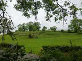
Photograph of Navan Fort, County Armagh |
|
Description
|
Photograph of Navan Fort, County Armagh |
|
Type
|
Image |
|
Format
|
image/jpeg |
|
Extent
|
11.77mb |
|
Copyrights
|
Copyright © The Discovery Programme
Creative Commons - Attribution, Non-Commercial, No Derivatives (BY-NC-ND)
|
|
Link
|
 |
|
Landing Page
|
 |
|
Metadata
|
Information
|
|
Thumbnail
|

|
|
Name
|
Digital terrain model (DTM) of Navan Fort, County Armagh |
|
Description
|
Digital terrain model (DTM) of Navan Fort, County Armagh |
|
Type
|
Image |
|
Format
|
image/jpeg |
|
Extent
|
11.77mb |
|
Copyrights
|
Copyright © The Discovery Programme
Creative Commons - Attribution, Non-Commercial, No Derivatives (BY-NC-ND)
|
|
Link
|
|
|
Landing Page
|
|
|
Metadata
|
Information
|
|
Thumbnail
|

|
|
Name
|
Perspective view 1 of digital terrain model (DTM) of Navan Fort, County Armagh |
|
Description
|
Perspective view 1 of digital terrain model (DTM) of Navan Fort, County Armagh |
|
Type
|
Image |
|
Format
|
image/jpeg |
|
Extent
|
11.77mb |
|
Copyrights
|
Copyright © The Discovery Programme
Creative Commons - Attribution, Non-Commercial, No Derivatives (BY-NC-ND)
|
|
Link
|
|
|
Landing Page
|
|
|
Metadata
|
Information
|
|
Thumbnail
|

|
|
Name
|
Perspective view 2 of digital terrain model (DTM) of Navan Fort, County Armagh |
|
Description
|
Perspective view 2 of digital terrain model (DTM) of Navan Fort, County Armagh |
|
Type
|
Image |
|
Format
|
image/jpeg |
|
Extent
|
11.77mb |
|
Copyrights
|
Copyright © The Discovery Programme
Creative Commons - Attribution, Non-Commercial, No Derivatives (BY-NC-ND)
|
|
Link
|
|
|
Landing Page
|
|
|
Metadata
|
Information
|
|
Thumbnail
|

|
|
Name
|
Perspective view 3 of digital terrain model (DTM) of Navan Fort, County Armagh |
|
Description
|
Perspective view 3 of digital terrain model (DTM) of Navan Fort, County Armagh |
|
Type
|
Image |
|
Format
|
image/jpeg |
|
Extent
|
11.77mb |
|
Copyrights
|
Copyright © The Discovery Programme
Creative Commons - Attribution, Non-Commercial, No Derivatives (BY-NC-ND)
|
|
Link
|
|
|
Landing Page
|
|
|
Metadata
|
Information
|
|
Thumbnail
|

|
|
Name
|
Perspective view 4 of digital terrain model (DTM) of Navan Fort, County Armagh |
|
Description
|
Perspective view 4 of digital terrain model (DTM) of Navan Fort, County Armagh |
|
Type
|
Image |
|
Format
|
image/jpeg |
|
Extent
|
11.77mb |
|
Copyrights
|
Copyright © The Discovery Programme
Creative Commons - Attribution, Non-Commercial, No Derivatives (BY-NC-ND)
|
|
Link
|
|
|
Landing Page
|
|
|
Metadata
|
Information
|
|
Thumbnail
|

|
|
Name
|
Photograph of main mound at Navan Fort, County Armagh |
|
Description
|
Photograph of main mound at Navan Fort, County Armagh |
|
Type
|
Image |
|
Format
|
image/jpeg |
|
Extent
|
11.77mb |
|
Copyrights
|
Copyright © The Discovery Programme
Creative Commons - Attribution, Non-Commercial, No Derivatives (BY-NC-ND)
|
|
Link
|
|
|
Landing Page
|
|
|
Metadata
|
Information
|
|
Name
|
FLI-Map 400 Lidar Survey |
|
Description
|
FLI-MAP 400; an aerial LiDAR survey system, was initially designed to survey infrastructural assets such as roads, railways and electricity supply networks. The sensor system mounted beneath the main helicopter fuselage consists of:
Three 150 kHz LiDAR sensors (7◦ forward, nadir and 7◦ aft);
Scanning angle 60◦
Accuracy (relative) Horizontal 5 cm, Vertical 3 cm
Multiple returns 4
Two RTK GPS receivers – provide accurate location in used in conjunction with RTK base stations;
Inertial Navigation System (INS)- continuously track the position, orientation, and velocity of the helicopter;
Digital imaging (11 megapixel) and digital video capture.
Resulting data sets include first return (DSM) and last return point (DTM, basre earth) models
|
|
Purpose
|
Remote Sensing |
|
Techinques
|
Lidar survey |
|
Equipment
|
FLI-MAP 400 Lidar system |
|
Actor
|
BKS Fugro, Organisation, Data Capture |