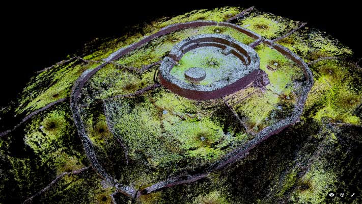
Dún Eochla Stone Fort (3D Sampled Pointcloud Model)
GA110-138----
In a prominent position, close to E end of a ridge, on Inis Mór. This Nat. Mon., known locally as Dún Eochla, is a restored bivallate cashel, defined by an inner oval drystone rampart (N-S 27.3m, E-W 22.7m) and an outer subrectangular one (N-S 76.1m, E-W 50.4m). The inner rampart has two internal terraces with interconnecting steps, and an entrance at NE. The interior contained two houses of which no visible surface trace survives; a circular clearance cairn now stands in the centre. The outer rampart, also partly terraced, has an entrance at SSE. (O'Flanagan 1927a, Vol. 3, 230-40; Weir 1980, 260; Westropp 1895, 260)
|
Metadata
|
Information
|
|
Source
|
The Discovery Programme |
|
Contacts
|
Mr Anthony Corns
Technology Manager
The Discovery Programme
63
Merrion Square
Dublin
D2
Dublin
Dublin
Ireland
+353 1 639 3039
+353 1 639 3710
info@discoveryprogramme.ie
The Discovery Programme
|
|
Copyright Credit Line
|
Copyright © The Discovery Programme |
|
Europeana Rights
|
Creative Commons - Attribution, Non-Commercial, No Derivatives (BY-NC-ND) |
|
Spatial
|
Dún Eochla, Aran Islands
|
|
Protection Type
|
National Monuments in State Care |
|
Start Date
|
400 |
|
End Date
|
800 |
|
Period Name
|
Early Christian Period |
|
Materials
|
Stone |
|
Heritage Asset Type
|
Ringfort - unclassified |
|
Metadata
|
Information
|
|
Thumbnail
|

|
|
Name
|
Decimated 3D point cloud model of Dún Eochla Stone Fort, Inis Mór |
|
Description
|
Decimated 3D point cloud model of Dún Eochla Stone Fort, Inis Mór(1% of full data) |
|
Type
|
3D |
|
Format
|
webGL |
|
Extent
|
11.77mb |
|
Copyrights
|
Copyright © The Discovery Programme
Creative Commons - Attribution, Non-Commercial, No Derivatives (BY-NC-ND)
|
|
Link
|
 |
|
Landing Page
|
 |
|
Metadata
|
Information
|
|
Name
|
Phase-based Terrestrial Laser Scanning |
|
Description
|
Phase based terrestrial laser scanning using a Faro Focus 120 laser scanner.
The instrument quotes the following specification: Distance accuracy up to ±2mm. Range from 0.6m up to 120m. Measurement rate up to 976,000 points/sec. Intensity & RGB. Integrated colour camera. Photorealistic 3D colour scans with up to 70 megapixels. Parallax-free colour overlay. |
|
Purpose
|
Measured survey |
|
Techinques
|
Georeferenced using RTK GPS with VRSnow corrections,Phased based terrestrial laser scanning |
|
Equipment
|
Trimble 5800 RTK GPS,Faro Focus 3D 120 |
|
Actor
|
Gary Devlin, Individual, Geo-surveyor |
|
Actor
|
Robert Shaw, Individual, Senior Geo-surveyor |