Newgrange Complex, Co. Meath (Images)
Newgrange, the best known Irish passage tomb, is surrounded by a kerb of 97 stones, the most impressive of which is the highly decorated Entrance Stone. The mound covers a single tomb consisting of a long passage and a cross-shaped chamber. There are the remains of two smaller tombs immediately to the west of Newgrange and at least one and probably two to the east.
Newgrange was excavated between 1962 and 1975 by Professor M. J. O’Kelly who discovered the Roof Box through which the mid-winter sun penetrates into the chamber. Based on archaeological evidence, he also designed the reconstruction of the white quartz façade.
|
Metadata
|
Information
|
|
Source
|
The Discovery Programme |
|
Contacts
|
Mr Anthony Corns
Technology Manager
The Discovery Programme
63
Merrion Square
Dublin
D2
Dublin
Dublin
Ireland
+353 1 639 3039
+353 1 639 3710
info@discoveryprogramme.ie
The Discovery Programme
|
|
Copyright Credit Line
|
Copyright © The Discovery Programme |
|
Europeana Rights
|
Creative Commons - Attribution, Non-Commercial, No Derivatives (BY-NC-ND) |
|
Spatial
|
Passage Tomb Chamber, Newgrange
|
|
Protection Type
|
National Monuments in State Care |
|
Start Date
|
-4000 |
|
End Date
|
-2500 |
|
Period Name
|
Neolithic Period |
|
Heritage Asset Type
|
Megalithic tomb - passage tomb |
|
Metadata
|
Information
|
|
Thumbnail
|

|
|
Name
|
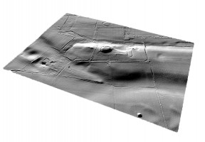
Perspective view 1 of the Newgrange Archaeological Complex digital terrain model (DTM) |
|
Description
|
Perspective view 1 of the Newgrange Archaeological Complex digital terrain model (DTM) |
|
Type
|
Image |
|
Format
|
image/jpeg |
|
Extent
|
11.77mb |
|
Copyrights
|
Copyright © The Discovery Programme
Creative Commons - Attribution, Non-Commercial, No Derivatives (BY-NC-ND)
|
|
Link
|
 |
|
Landing Page
|
 |
|
Metadata
|
Information
|
|
Thumbnail
|

|
|
Name
|
Perspective view 3 of the Newgrange Archaeological Complex digital terrain model (DTM) |
|
Description
|
Perspective view 3 of the Newgrange Archaeological Complex digital terrain model (DTM) |
|
Type
|
Image |
|
Format
|
image/jpeg |
|
Extent
|
11.77mb |
|
Copyrights
|
Copyright © The Discovery Programme
Creative Commons - Attribution, Non-Commercial, No Derivatives (BY-NC-ND)
|
|
Link
|
|
|
Landing Page
|
|
|
Metadata
|
Information
|
|
Thumbnail
|

|
|
Name
|
Perspective view 2 of the Newgrange Archaeological Complex digital terrain model (DTM) |
|
Description
|
Perspective view 2 of the Newgrange Archaeological Complex digital terrain model (DTM) |
|
Type
|
Image |
|
Format
|
image/jpeg |
|
Extent
|
11.77mb |
|
Copyrights
|
Copyright © The Discovery Programme
Creative Commons - Attribution, Non-Commercial, No Derivatives (BY-NC-ND)
|
|
Link
|
|
|
Landing Page
|
|
|
Metadata
|
Information
|
|
Thumbnail
|

|
|
Name
|
Perspective view 4 of the Newgrange Archaeological Complex digital terrain model (DTM) |
|
Description
|
Perspective view 4 of the Newgrange Archaeological Complex digital terrain model (DTM) |
|
Type
|
Image |
|
Format
|
image/jpeg |
|
Extent
|
11.77mb |
|
Copyrights
|
Copyright © The Discovery Programme
Creative Commons - Attribution, Non-Commercial, No Derivatives (BY-NC-ND)
|
|
Link
|
|
|
Landing Page
|
|
|
Metadata
|
Information
|
|
Thumbnail
|

|
|
Name
|
Plan view of the Newgrange Archaeological Complex digital terrain model (DTM) |
|
Description
|
Plan view of the Newgrange Archaeological Complex digital terrain model (DTM) |
|
Type
|
Image |
|
Format
|
image/jpeg |
|
Extent
|
11.77mb |
|
Copyrights
|
Copyright © The Discovery Programme
Creative Commons - Attribution, Non-Commercial, No Derivatives (BY-NC-ND)
|
|
Link
|
|
|
Landing Page
|
|
|
Metadata
|
Information
|
|
Thumbnail
|

|
|
Name
|
Vertical aerial image of the Newgrange Archaeological Complex |
|
Description
|
Vertical aerial image of the Newgrange Archaeological Complex |
|
Type
|
Image |
|
Format
|
image/jpeg |
|
Extent
|
11.77mb |
|
Copyrights
|
Copyright © The Discovery Programme
Creative Commons - Attribution, Non-Commercial, No Derivatives (BY-NC-ND)
|
|
Link
|
|
|
Landing Page
|
|
|
Metadata
|
Information
|
|
Name
|
Fixed wing Lidar Survey |
|
Description
|
The ALTM 3100 instrument is mounted on a fixed wing platform leased 365 days per year by the Agency as it forms the core mapping work undertaken. This system will be used for the proposed contract. LIDAR data will be collected at an altitude of approximately 900m, which with a scan angle of +/- 20º will result in a swath of 750m. LIDAR data will be collected at a density of approximately 1m resolution or one point per square metre.
All GPS ground data is collected and processed using the in-house developed and quality assured procedures EASGT_019 and EASGT_020. |
|
Purpose
|
Remote Sensing |
|
Techinques
|
Lidar Survey |
|
Equipment
|
Optech ALTM 3100 |