Reefert high cross, Glendalough (Images)
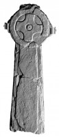
High cross originally located at the Reefert's Church at Glendalough, now located in the Visitors center. Possibly dates to the ninth or tenth century, with rebated edges
|
Metadata
|
Information
|
|
Source
|
The Discovery Programme |
|
Contacts
|
Mr Anthony Corns
Technology Manager
The Discovery Programme
63
Merrion Square
Dublin
D2
Dublin
Dublin
Ireland
+353 1 639 3039
+353 1 639 3710
info@discoveryprogramme.ie
The Discovery Programme
|
|
Copyright Credit Line
|
Copyright © The Discovery Programme |
|
Europeana Rights
|
Creative Commons - Attribution, Non-Commercial, No Derivatives (BY-NC-ND) |
|
Spatial
|
Reefert Church, Glendalough
|
|
Protection Type
|
National Monuments in State Care |
|
Start Date
|
400 |
|
End Date
|
800 |
|
Period Name
|
Early Medieval |
|
Period Name
|
10th century AD |
|
Period Name
|
9th Century AD |
|
Materials
|
Stone |
|
Heritage Asset Type
|
High cross |
|
Metadata
|
Information
|
|
Thumbnail
|

|
|
Name
|
Image of Reefert high cross 3D untextured scan model, Glendalough |
|
Description
|
Image of Reefert high cross 3D untextured scan model, Glendalough, produced using Artec handheld scanner |
|
Type
|
Image |
|
Format
|
image/jpeg |
|
Copyrights
|
Copyright ©The Discovery Programme
Creative Commons - Attribution, Non-Commercial, No Derivatives (BY-NC-ND)
|
|
Link
|
 |
|
Landing Page
|
 |
|
Metadata
|
Information
|
|
Thumbnail
|

|
|
Name
|
Perspective image of Reefert high cross 3D untextured scan model, Glendalough |
|
Description
|
Perspective image of Reefert high cross 3D untextured scan model, Glendalough, produced using Artec handheld scanner |
|
Type
|
Image |
|
Format
|
image/jpeg |
|
Copyrights
|
Copyright ©The Discovery Programme
Creative Commons - Attribution, Non-Commercial, No Derivatives (BY-NC-ND)
|
|
Link
|
|
|
Landing Page
|
|
|
Metadata
|
Information
|
|
Thumbnail
|

|
|
Name
|
Photograph of Reefert high cross, Glendalough |
|
Description
|
Photograph of Reefert high cross, Glendalough, produced using Artec handheld scanner |
|
Type
|
Image |
|
Format
|
image/jpeg |
|
Copyrights
|
Copyright ©The Discovery Programme
Creative Commons - Attribution, Non-Commercial, No Derivatives (BY-NC-ND)
|
|
Link
|
|
|
Landing Page
|
|
|
Metadata
|
Information
|
|
Name
|
Close Range Scanning, Glendalough |
|
Description
|
The Artec EVA scanner is used to generate high resolution models of surfaces with small scale detail. The Artec EVA uses structured light to record. A forensics tent is used to create a controlled lighting environment and ensure measurement can proceed regardless of the weather when used outdoors. Scanning is undertaken with the fastest speed setting (15 frames per second) and with a minimum 400 mm depth of field. The data is recorded with sufficient overlap between scans to ensure easy registration.
Resolution 0.5 mm
Accuracy 0.1 mm
Accuracy over distance 0.03% over 100 cm
Texture Resolution 1.3 mp
Colours 24 bpp
Light Source flash bulb (no laser)
Video frame rate 16 fps
Exposure time 0.0002 s
Post-processing is done in Artec Studio 9 software: individual scans are edited, aligned, before a final surface is generated using global registration, fusion, and a small objects filter algorithm. If required, a textured surface can also be created. The model is exported from Artec Studio 9 as an .obj file. For dissemination purposes a 3D pdf of the model is generated using Geomagic Studio 2012. |
|
Purpose
|
Measured Survey |
|
Equipment
|
Artec Studio 9.2,Artec EVA ,HP Computer,Artec Studio 9.2,HP Computer |
|
Actor
|
Gary Devlin, Individual, Geo-surveyor |