Cell F, Skellig Michael (High resolution 3D point cloud model)
KE104A001038-
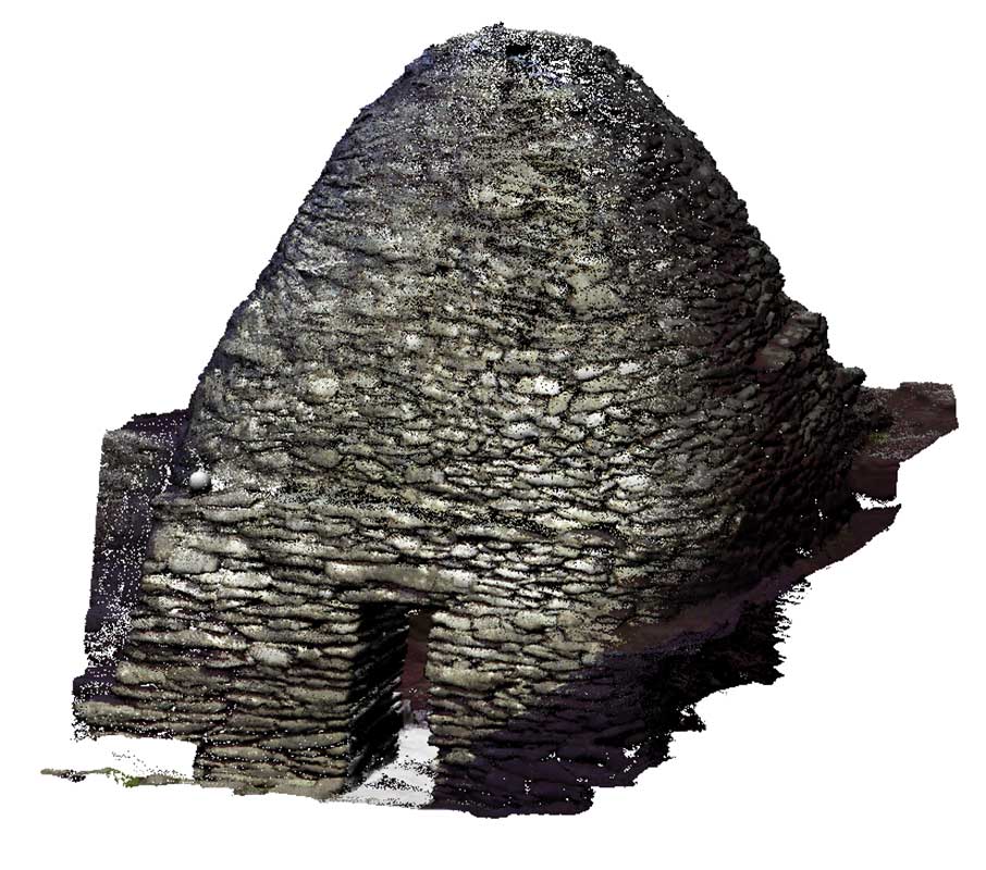
Cell F, to the south-east of Cell E, is built of moderately sized stones. It measures 2.98m by 2.75m, with the corners defined up to about 60cm above the lintel, after which it becomes circular. A stone with a circular opening completes the dome; it is unclear whether this is an original feature. There are three cupboards in the walls and projecting stone pegs. The floor is irregularly paved and includes some upright slabs that define a raised section on three sides, which may have been where the monks slept.
SKELLIG MICHAEL, CO. KERRY: THE MONASTERY AND SOUTH PEAK Archaeological stratigraphic report: excavations 1986–2010 Edward Bourke, Alan R. Hayden, Ann Lynch
|
Metadata
|
Information
|
|
Source
|
The Discovery Programme |
|
Contacts
|
Mr Anthony Corns
Technology Manager
The Discovery Programme
63
Merrion Square
Dublin
D2
Dublin
Dublin
Ireland
+353 1 639 3039
+353 1 639 3710
info@discoveryprogramme.ie
The Discovery Programme
|
|
Copyright Credit Line
|
Copyright © The Discovery Programme |
|
Europeana Rights
|
Creative Commons - Attribution, Non-Commercial, No Derivatives (BY-NC-ND) |
|
Spatial
|
Cell F, skellig Michael
|
|
Protection Type
|
National Monuments in State Care |
|
Start Date
|
400 |
|
End Date
|
800 |
|
Period Name
|
Early Christian Period |
|
Materials
|
Stone |
|
Heritage Asset Type
|
Clochan |
|
Metadata
|
Information
|
|
Thumbnail
|

|
|
Name
|
High resolution 3D point cloud model of Cell F, Skellig Michael |
|
Description
|
High resolution 3D point cloud model of Cell F, Skellig Michael |
|
Type
|
3D |
|
Format
|
xyz |
|
Copyrights
|
Copyright © The Discovery Programme
Paid access_no re_use
|
|
Link
|
 |
|
Landing Page
|
 |
|
Metadata
|
Information
|
|
Name
|
Phase-based Terrestrial Laser Scanning |
|
Description
|
Phase based terrestrial laser scanning using a Faro Focus 120 laser scanner.
The instrument quotes the following specification: Distance accuracy up to ±2mm. Range from 0.6m up to 120m. Measurement rate up to 976,000 points/sec. Intensity & RGB. Integrated colour camera. Photorealistic 3D colour scans with up to 70 megapixels. Parallax-free colour overlay. |
|
Purpose
|
Measured survey |
|
Techinques
|
Georeferenced using RTK GPS with VRSnow corrections,Phased based terrestrial laser scanning |
|
Equipment
|
Trimble 5800 RTK GPS,Faro Focus 3D 120 |
|
Actor
|
Gary Devlin, Individual, Geo-surveyor |
|
Actor
|
Robert Shaw, Individual, Senior Geo-surveyor |