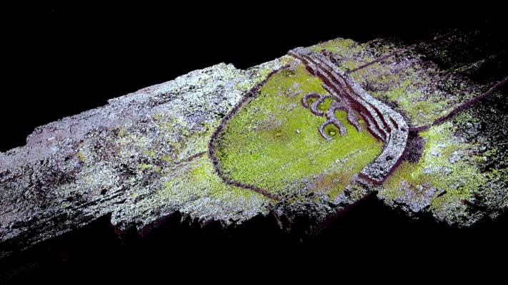
Dúcathair Stone Fort (3D decimated point cloud model)
GA119-001----
On a sheer cliff-top headland on SW side of Inis Mór. This Nat. Mon. is known locally as Dún Dúcathair. It consists of an irregular boulder-strewn area of limestone pavement (110m by 80m max.) defined to landward (NE) by a massive drystone rampart (L c. 73m, Wth 7.2m, H 3.7m). Both the inner face of the rampart, with three terraces connected by steps, and the buttressed outer face are the result of 19th-C restoration. Traces of an entrance (Wth 2.2m) survive at E end but Westropp, citing Petrie in 1821, states that it 'had a perfect entrance to the west, destroyed ... by a great cliff-fall before 1839' (1914, 333-4). Outside the rampart is a dense band of chevaux-de-frise (Wth 55m max.) and within it are two groups of houses (GA119-001001-, GA119-002----). (O'Flanagan 1927a, Vol. 3, 242-50; Westropp 1914, 333-4; Robinson 1986, 37-40)
|
Metadata
|
Information
|
|
Source
|
The Discovery Programme |
|
Contacts
|
Mr Anthony Corns
Technology Manager
The Discovery Programme
63
Merrion Square
Dublin
D2
Dublin
Dublin
Ireland
+353 1 639 3039
+353 1 639 3710
info@discoveryprogramme.ie
The Discovery Programme
|
|
Copyright Credit Line
|
Copyright © The Discovery Programme |
|
Europeana Rights
|
Creative Commons - Attribution, Non-Commercial, No Derivatives (BY-NC-ND) |
|
Spatial
|
Ducathair fort
|
|
Protection Type
|
National Monuments in State Care |
|
Start Date
|
-500 |
|
End Date
|
400 |
|
Period Name
|
Iron Age Period |
|
Materials
|
Stone |
|
Heritage Asset Type
|
Promontory fort - coastal |
|
Metadata
|
Information
|
|
Thumbnail
|

|
|
Name
|
Decimated 3D point cloud model of Ducathair Stone Fort, Inis Mor |
|
Description
|
Decimated 3D point cloud model of Ducathair Stone Fort, Inis Mor (1% of full data) |
|
Type
|
3D |
|
Format
|
webGL |
|
Extent
|
11.77mb |
|
Copyrights
|
Copyright © The Discovery Programme
Creative Commons - Attribution, Non-Commercial, No Derivatives (BY-NC-ND)
|
|
Link
|
 |
|
Landing Page
|
 |
|
Metadata
|
Information
|
|
Name
|
Phase-based Terrestrial Laser Scanning |
|
Description
|
Phase based terrestrial laser scanning using a Faro Focus 120 laser scanner.
The instrument quotes the following specification: Distance accuracy up to ±2mm. Range from 0.6m up to 120m. Measurement rate up to 976,000 points/sec. Intensity & RGB. Integrated colour camera. Photorealistic 3D colour scans with up to 70 megapixels. Parallax-free colour overlay. |
|
Purpose
|
Measured survey |
|
Techinques
|
Georeferenced using RTK GPS with VRSnow corrections,Phased based terrestrial laser scanning |
|
Equipment
|
Trimble 5800 RTK GPS,Faro Focus 3D 120 |
|
Actor
|
Gary Devlin, Individual, Geo-surveyor |
|
Actor
|
Robert Shaw, Individual, Senior Geo-surveyor |