The Cenacle and the Tomb of King David in Jerusalem, plan
|
|
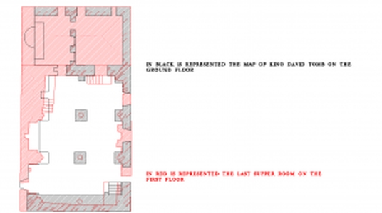
This is a drawing is the result of two different plans overlapped. The black colour represents the room of tomb of King David while the red stands for the Cenacle.
| Metadata | Information |
| Source | The Cyprus Institute - STARC |
| Europeana Rights |
|
| Heritage Asset Type | Heritage building |
| Metadata | Information |
| Thumbnail |

|
| Name | Drawing of the two plans of the cenacle and the tomb of King David together |
| Description | This is a drawing is the result of two different plans overlapped. The black colour represents the room of tomb of King David while the red stands for the Cenacle. |
| Type | Image |
| Link |
 |
| Landing Page |
|
| Metadata | Information |
| Name | Photographic campaign, Jerusalem |
| Description | Photographic campaign for the documentation of the Cenacle and the Tomb of King David in Jerusalem |
| Techinques | Photography |