Image of the archaeological site of Dromolaxia - Vizakia (Hala Sultan Tekke), Magnetic Gradiometer System
|
|
|
Metadata
|
Information
|
|
Appellation
|
Image of the archaeological site of Dromolaxia - Vizakia (Hala Sultan Tekke), Magnetic Gradiometer System |
|
Address
|
Larnaca, Larnaca, Cyprus |
|
Coordinates (Lat, Lon)
|
(34.886370 , 33.604243)
Click to view it on Google Maps |
|
See it on Europeana
|
 |
|
Link
|
 |
|
Landing Page
|
 |
|
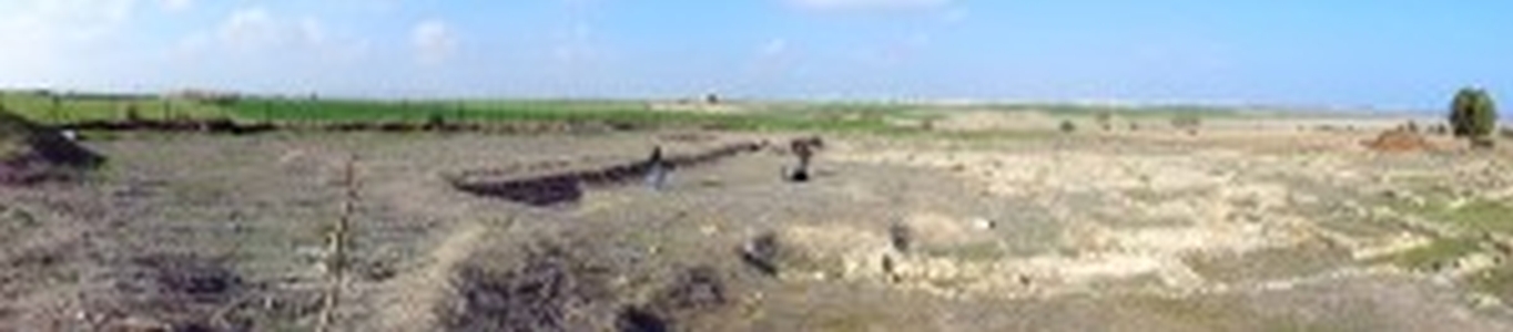
This is a panoramic image that shows the archaeological site of Dromolaxia - Vizakia (Hala Sultan Tekke) in Larnaca. More specifically the picture depicts members of the STARC team using the Magnetic Gradiometer System during the geophysical survey that took place at the excavation site (Building C, Area 8) in January 2014. The Grad601 is a vertical component fluxgate gradiometer, comprising a data logger, battery cassette and has two Grad-01-1000L cylindrical sensors mounted on a rigid carrying bar. Each sensor contains two fluxgate magnetometers with one metre vertical separation. Adjustments to remove the small residual errors are made automatically, requiring the operator only to rotate the gradiometer in response to instructions from the Data Logger. Calibration of the gradiometer is by simple push-button control, eliminating the uncertainties usually associated with mechanically adjusted instruments. The instrument operates in either survey or scanning mode. In survey mode, data is logged using continuous or single-shot measurements, while covering the site in parallel or zigzag paths. In scanning mode, the instrument operates as a search tool with an adjustable audio alarm, without logging data. Either mode can be used to locate archaeological features, pipes, cables, waste drums and unexploded ordnance. Survey data are saved in grids of 10, 20, 30 or 40 m².
|
Metadata
|
Information
|
|
Source
|
The Cyprus Institute - STARC |
|
Europeana Rights
|
Free access_no re_use |
|
Heritage Asset Type
|
Archaeological area |
|
Metadata
|
Information
|
|
Thumbnail
|

|
|
Name
|
Image of the archaeological site of Dromolaxia - Vizakia (Hala Sultan Tekke), Magnetic Gradiometer System |
|
Description
|
This is a panoramic image that shows the archaeological site of Dromolaxia - Vizakia (Hala Sultan Tekke) in Larnaca. More specifically the picture depicts members of the STARC team using the Magnetic Gradiometer System during the geophysical survey that took place at the excavation site (Building C, Area 8) in January 2014. The Grad601 is a vertical component fluxgate gradiometer, comprising a data logger, battery cassette and has two Grad-01-1000L cylindrical sensors mounted on a rigid carrying bar. Each sensor contains two fluxgate magnetometers with one metre vertical separation. Adjustments to remove the small residual errors are made automatically, requiring the operator only to rotate the gradiometer in response to instructions from the Data Logger. Calibration of the gradiometer is by simple push-button control, eliminating the uncertainties usually associated with mechanically adjusted instruments. The instrument operates in either survey or scanning mode. In survey mode, data is logged using continuous or single-shot measurements, while covering the site in parallel or zigzag paths. In scanning mode, the instrument operates as a search tool with an adjustable audio alarm, without logging data. Either mode can be used to locate archaeological features, pipes, cables, waste drums and unexploded ordnance. Survey data are saved in grids of 10, 20, 30 or 40 m². |
|
Type
|
Image |
|
Link
|
 |
|
Landing Page
|
|
|
Metadata
|
Information
|
|
Name
|
Photographic campaign, the archaeological site of Dromolaxia - Vizakia (Hala Sultan Tekke), Larnaca |
|
Description
|
Photographic campaign for the documentation of the excavation area of Dromolaxia - Vizakia (Hala Sultan Tekke), Larnaca |
