The Cenacle and the Tomb of King David in Jerusalem, corridor
|
|
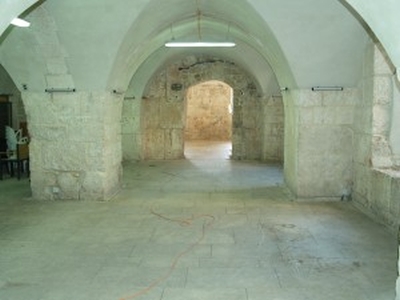
This image shows corridor leading towards the tomb of King David (men's sector) and the targets positioned on the wall during 3D scanning session.
| Metadata | Information |
| Source | The Cyprus Institute - STARC |
| Europeana Rights |
|
| Heritage Asset Type | Heritage building |
| Metadata | Information |
| Thumbnail |

|
| Name | Image of the corridor leading towards the tomb of King David |
| Description | This image shows corridor leading towards the tomb of King David (men's sector) and the targets positioned on the wall during 3D scanning session. |
| Type | Image |
| Link |
 |
| Landing Page |
|
| Metadata | Information |
| Name | Photographic campaign, Jerusalem |
| Description | Photographic campaign for the documentation of the Cenacle and the Tomb of King David in Jerusalem |
| Techinques | Photography |