The archaeological site of tombs of the Kings, image of Plan A, atrium
|
|
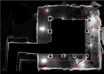
This is a snapshot taken from MeshLab. The image shows the mesh of the 3D model created during the 3D documentation of Tomb 4 in March 2014. More specifically this image shows the atrium in Tomb 4 (top view) with the cracks highlighted in red colour.
| Metadata | Information |
| Source | The Cyprus Institute - STARC |
| Europeana Rights |
|
| Heritage Asset Type | Archaeological site |
| Metadata | Information |
| Thumbnail |

|
| Name | The archaeological site of tombs of the Kings, image of Plan A, atrium |
| Description | This is a snapshot taken from MeshLab. The image shows the mesh of the 3D model created during the 3D documentation of Tomb 4 in March 2014. More specifically this image shows the atrium in Tomb 4 (top view) with the cracks highlighted in red colour. |
| Type | Image |
| Link |
 |
| Landing Page |
|
| Metadata | Information |
| Name | Snapshots from 3D model |
| Description | Snapshots related to the 3D models of the Tombs of the Kings archaeological site in Paphos. |