Image of the archaeological site of Dromolaxia - Vizakia (Hala Sultan Tekke), total station
|
|
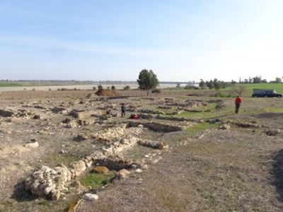
This image shows the archaeological site of Dromolaxia - Vizakia (Hala Sultan Tekke) in Larnaca. More specifically the picture depicts members of the STARC team collecting data by using the total station during the geophysical survey that took place at the excavation site (Building C, Area 8) in January 2014.
| Metadata | Information |
| Source | The Cyprus Institute - STARC |
| Europeana Rights |
|
| Heritage Asset Type | Archaeological area |
| Metadata | Information |
| Thumbnail |

|
| Name | Image of the archaeological site of Dromolaxia - Vizakia (Hala Sultan Tekke), total station |
| Description | This image shows the archaeological site of Dromolaxia - Vizakia (Hala Sultan Tekke) in Larnaca. More specifically the picture depicts members of the STARC team collecting data by using the total station during the geophysical survey that took place at the excavation site (Building C, Area 8) in January 2014. |
| Type | Image |
| Link |
 |
| Landing Page |
|
| Metadata | Information |
| Name | Photographic campaign, the archaeological site of Dromolaxia - Vizakia (Hala Sultan Tekke), Larnaca |
| Description | Photographic campaign for the documentation of the excavation area of Dromolaxia - Vizakia (Hala Sultan Tekke), Larnaca |