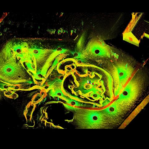
LiDAR Scan of House 8, Skara Brae
Point cloud model derived from LiDAR survey of the monument.
Skara Brae is an archaeological site with exceptionally well preserved remains that show the stone built furniture and internal structure of ten Neolithic houses and their narrow connecting passageways. Radio Carbon dates show that the village was occupied for around 600 years between 3200 and 2200 BC. There appear to be two main structural phases to the occupation.
House 8 lies on its own, slightly to the west of the main village from which is separated by a paved area that has been called the ‘market place’. Although of similar size to the later houses, House 8 has very different internal features internal features. It may be one of the latest houses on the site. Where the beds would have been were alcoves and around a smaller hearth the excavators in the 1920s found fragments of chert and other debris from the making of tools.
The monument is now managed by Historic Scotland and is a key element of the Heart of Neolithic Orkney World Heritage Site. The Lidar survey was conducted by Scottish10 and made available by Centre for Digital Documentation and Visualisation (CDDV).
|
Metadata
|
Information
|
|
Source
|
Historic Scotland |
|
Contacts
|
Lyn Wilson
CDDV
|
|
Copyright Credit Line
|
© Historic Scotland |
|
Europeana Rights
|
Paid access_no re_use |
|
Spatial
|
Skara Brae
|
|
Start Date
|
3180 BCE |
|
End Date
|
2500 BCE |
|
Period Name
|
Neolithic |
|
Materials
|
Dry Stone |
|
Heritage Asset Type
|
Settlement |
|
Metadata
|
Information
|
|
Thumbnail
|

|
|
Name
|
House 08 Scan Data |
|
Description
|
Leica scan of House 8.
Collection of 27 scans, totalling 166 million points. |
|
Type
|
3D |
|
Format
|
Leica PTX |
|
Copyrights
|
CDDV
Paid access_no re_use
|
|
Landing Page
|
 |
|
Metadata
|
Information
|
|
Name
|
Terrestrial Laser Scan |
|
Actor
|
CDDV, Group |