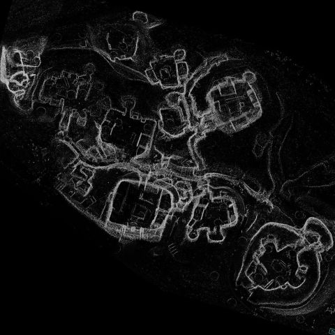
Point cloud model derived from LiDAR survey of the monument.
Skara Brae is an archaeological site with exceptionally well preserved remains that show the stone built furniture and internal structure of ten Neolithic houses and their narrow connecting passageways. Radio Carbon dates show that the village was occupied for around 600 years between 3200 and 2200 BC. It was then abandoned but largely preserved beneath a large mound of collapsed midden and sand. Changes in sea-level and the formation of the Bay of Skaill had perhaps made the site less attractive to the inhabitants. Eventually erosion and sea-level changes placed Skara Brae on the shoreline. In 1850 winter storms exposed several of the houses. It is possible that some parts of Skara Brae were eroded before then - but since the the 1850s archaeologists have worked to record and preserve the surviving houses. Between 1850 and 1898 the remains of four houses were explored. Then in 1925 another great storm damaged and exposed more of the site. Between 1928 and 1930 the houses we see today were excavated and then consolidated. A defensive sea wall was built at that time to protect the site but rising sea levels will be a future threat.
The monument is now managed by Historic Scotland and is a key element of the Heart of Neolithic Orkney World Heritage Site. The Lidar survey was conducted by Scottish10 and made available by Centre for Digital Documentation and Visualisation (CDDV).
|
Metadata
|
Information
|
|
Source
|
Historic Scotland |
|
Contacts
|
Lyn Wilson
CDDV
|
|
Copyright Credit Line
|
© Historic Scotland |
|
Europeana Rights
|
The Creative Commons CC0 1.0 Universal Public Domain Dedication (CC0) |
|
Spatial
|
Skara Brae
|
|
Start Date
|
3180 BCE |
|
End Date
|
2500 BCE |
|
Period Name
|
Neolithic |
|
Materials
|
Dry Stone |
|
Heritage Asset Type
|
Settlement |