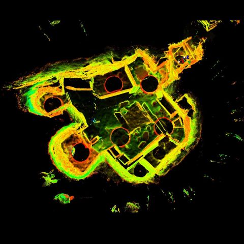
LiDAR Scan of House 2, Skara Brae
Point cloud model derived from LiDAR survey of the monument.
Skara Brae is an archaeological site with exceptionally well preserved remains that show the stone built furniture and internal structure of ten Neolithic houses and their narrow connecting passageways. Radio Carbon dates show that the village was occupied for around 600 years between 3200 and 2200 BC. There appear to be two main structural phases to the occupation.
House 2 lies on what is now the northern edge of the village. As seen today House 2 is the smallest of the later houses at Skara Brae. The floor area is nevertheless organised in a similar way with rectangular beds around a central hearth. There are a number of substantial chambers within the walls of this house which help to increase it’s usable space.
The monument is now managed by Historic Scotland and is a key element of the Heart of Neolithic Orkney World Heritage Site. The Lidar survey was conducted by Scottish10 and made available by Centre for Digital Documentation and Visualisation (CDDV).
|
Metadata
|
Information
|
|
Source
|
Historic Scotland |
|
Contacts
|
Lyn Wilson
CDDV
|
|
Copyright Credit Line
|
© Historic Scotland |
|
Europeana Rights
|
Paid access_no re_use |
|
Spatial
|
Skara Brae
|
|
Start Date
|
3180 BCE |
|
End Date
|
2500 BCE |
|
Period Name
|
Neolithic |
|
Materials
|
Dry Stone |
|
Heritage Asset Type
|
Settlement |
|
Metadata
|
Information
|
|
Thumbnail
|

|
|
Name
|
House 02 scan data |
|
Description
|
Collection of 9 Leica scans, totalling 50million points. |
|
Type
|
3D |
|
Format
|
Leica PTX |
|
Copyrights
|
Historic Scotland
Paid access_no re_use
|
|
Landing Page
|
 |
|
Metadata
|
Information
|
|
Name
|
Terrestrial Laser Scan |
|
Actor
|
CDDV, Group |