Double Bastion, Derry City Walls (Images)
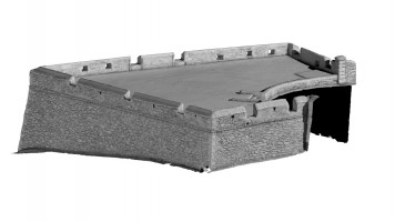
Double Bastion occupies the south-west corner of the layout of the walls and, following removal of surrounding nineteenth century housing in Nailor’s Row, is one of the most prominent parts of the Monument and the site of one of the best known cannon ‘Roaring Meg’. The bastion
is separated from the rampart walkway by a low stone plinth wall and, during the nineteenth century, was planted as a private garden.
NI SMR No.: LDY014:033
|
Metadata
|
Information
|
|
Source
|
The Discovery Programme |
|
Contacts
|
Mr Anthony Corns
Technology Manager
The Discovery Programme
63
Merrion Square
Dublin
D2
Dublin
Dublin
Ireland
+353 1 639 3039
+353 1 639 3710
info@discoveryprogramme.ie
The Discovery Programme
|
|
Copyright Credit Line
|
Copyright © The Discovery Programme |
|
Europeana Rights
|
Creative Commons - Attribution, Non-Commercial, No Derivatives (BY-NC-ND) |
|
Spatial
|
Double Bastion, Derry City Walls
|
|
Protection Type
|
National Monuments in State Care Northern Ireland |
|
Start Date
|
1600 |
|
End Date
|
1800 |
|
Period Name
|
Post Medieval Period |
|
Period Name
|
17th Century AD |
|
Materials
|
Sandstone, Schist, Stone |
|
Heritage Asset Type
|
Bastion |
|
Metadata
|
Information
|
|
Thumbnail
|

|
|
Name
|
Front isometric view 2 of Double Bastion, Derry City Walls |
|
Description
|
Front isometric view 2 of Double Bastion, Derry City Walls |
|
Type
|
Image |
|
Format
|
image/jpeg |
|
Copyrights
|
Copyright ©The Discovery Programme
Creative Commons - Attribution, Non-Commercial, No Derivatives (BY-NC-ND)
|
|
Link
|
 |
|
Landing Page
|
 |
|
Metadata
|
Information
|
|
Thumbnail
|

|
|
Name
|
Front isometric view 1 of Double Bastion, Derry City Walls |
|
Description
|
Front isometric view 1 of Double Bastion, Derry City Walls |
|
Type
|
Image |
|
Format
|
image/jpeg |
|
Copyrights
|
Copyright ©The Discovery Programme
Creative Commons - Attribution, Non-Commercial, No Derivatives (BY-NC-ND)
|
|
Link
|
|
|
Landing Page
|
|
|
Metadata
|
Information
|
|
Thumbnail
|

|
|
Name
|
Front elevation of Double Bastion, Derry City Walls |
|
Description
|
Front elevation of Double Bastion, Derry City Walls |
|
Type
|
Image |
|
Format
|
image/jpeg |
|
Copyrights
|
Copyright ©The Discovery Programme
Creative Commons - Attribution, Non-Commercial, No Derivatives (BY-NC-ND)
|
|
Link
|
|
|
Landing Page
|
|
|
Metadata
|
Information
|
|
Thumbnail
|

|
|
Name
|
Plan view of Double Bastion, Derry City Walls |
|
Description
|
Plan view of Double Bastion, Derry City Walls |
|
Type
|
Image |
|
Format
|
image/jpeg |
|
Copyrights
|
Copyright ©The Discovery Programme
Creative Commons - Attribution, Non-Commercial, No Derivatives (BY-NC-ND)
|
|
Link
|
|
|
Landing Page
|
|
|
Metadata
|
Information
|
|
Thumbnail
|

|
|
Name
|
Rear elevation of Double Bastion, Derry City Walls |
|
Description
|
Rear elevation of Double Bastion, Derry City Walls |
|
Type
|
Image |
|
Format
|
image/jpeg |
|
Copyrights
|
Copyright ©The Discovery Programme
Creative Commons - Attribution, Non-Commercial, No Derivatives (BY-NC-ND)
|
|
Link
|
|
|
Landing Page
|
|
|
Metadata
|
Information
|
|
Thumbnail
|

|
|
Name
|
Rear isometric view 1 of Double Bastion, Derry City Walls |
|
Description
|
Rear isometric view 1 of Double Bastion, Derry City Walls |
|
Type
|
Image |
|
Format
|
image/jpeg |
|
Copyrights
|
Copyright ©The Discovery Programme
Creative Commons - Attribution, Non-Commercial, No Derivatives (BY-NC-ND)
|
|
Link
|
|
|
Landing Page
|
|
|
Metadata
|
Information
|
|
Thumbnail
|

|
|
Name
|
Rear isometric view 2 of Double Bastion, Derry City Walls |
|
Description
|
Rear isometric view 2 of Double Bastion, Derry City Walls |
|
Type
|
Image |
|
Format
|
image/jpeg |
|
Copyrights
|
Copyright ©The Discovery Programme
Creative Commons - Attribution, Non-Commercial, No Derivatives (BY-NC-ND)
|
|
Link
|
|
|
Landing Page
|
|
|
Metadata
|
Information
|
|
Name
|
Phase-based Terrestrial Laser Scanning |
|
Description
|
Phase based terrestrial laser scanning using a Faro Focus 120 laser scanner.
The instrument quotes the following specification: Distance accuracy up to ±2mm. Range from 0.6m up to 120m. Measurement rate up to 976,000 points/sec. Intensity & RGB. Integrated colour camera. Photorealistic 3D colour scans with up to 70 megapixels. Parallax-free colour overlay. |
|
Purpose
|
Measured survey |
|
Techinques
|
Georeferenced using RTK GPS with VRSnow corrections,Phased based terrestrial laser scanning |
|
Equipment
|
Trimble 5800 RTK GPS,Faro Focus 3D 120 |
|
Actor
|
Gary Devlin, Individual, Geo-surveyor |
|
Actor
|
Robert Shaw, Individual, Senior Geo-surveyor |