Cahergal Stone Fort (Images)
|
|
Known locally as Cahergal/An Chathair Gheal, this impressive monument is the most southerly of a group of three cahers situated on the N side of the Valencia river estuary. It is located on the crest of a slight ridge, and its N sector is skirted by a low rock-face. The site consists of a massive circular rampart, which features terraces and interconnecting steps on its inner face, and encloses a large central hut. The hut was recently excavated (Manning 1991, 37; 1992, 24-5) as part of the extensive programme of repair and conservation being carried out on the site by the OPW.
Prior to its restoration the enclosing rampart of the caher was breached at NNE and its external face had collapsed at S and W. The original entrance, at SSE, was almost totally covered by collapse. A number of early photographs, including Lawrence Collection 4562WL, recorded the dilapidated state of the site at this time. The rampart survived to a maximum external height of 4m at SW, and consisted of a rubble core faced internally and externally with drystone masonry of exceptionally high quality. Averaging 5.5m in basal thickness, it featured a pronounced batter both internally and externally, and averaged 3.5m wide on top.
The basal courses of the original entrance feature were cleared of overlying collapse and reconstructed as a lintelled passage by the OPW. This is 5.7m long, 2m wide and 2m high. Two tall portal-like slabs project from the sides of the passage close to its inner end, where a large slab, set on edge, acts as a step-up to the interior of the site. Each of these three slabs are original features of the entrance passage. The inner face of the caher rampart features two terraces, on average 1.15m and 2.7m high above ground level, which are each divided into nine sections by inset arrangements of opposing steps. These sections average .6m wide and vary in length between 4.5m and 7.5m. The steps to the upper terrace tend to occur midway along the lengths of the individual sections of the lower one. At two points, at NNE and SW, access is gained to the top of the rampart from the upper terrace via sets of opposing steps.
The central hut is of drystone construction. Prior to excavation and conservation its interior was filled with rubble and its wall was only preserved above ground level at W, where it stood up to 1.7m high. Here it displayed a pronounced inward corbel and a number of slabs projected from its external face. Traces of an entrance were visible at SSE. Chatterton recorded a local tradition that the roof of the hut was of corbelled stone, and noted that a lamb shelter had been construted in its interior (1839, 280). Excavation revealed that the hut was 6.7m in internal diameter and featured two opposing entrances, each 1.1m wide. A third, blocked, entrance was located at N. Removal of the collapse in the interior of the hut revealed an occupation layer over the floor, a large central hearth-pit and several hundred stake-holes. There was little evidence for activity on the site prior to the construction of the hut. Artefacts recovered included quern fragments, scraps of sheet bronze, iron slag and tuyère fragments. Excavation between the caher entrance and the hut revealed a paving of stone flags flanked with low upright slabs.
Westropp and Henry recorded a large perforated slab lying outside the hut at SE (1912, 295; 1957, 63). This is no longer visible and was interpreted by Henry as a support slab for a timber door frame. Another slab lying in the interior of the caher, 2.45m x .7m x .15m thick, has two large circular depressions on its present upper surface.
A drystone structure of rectangular plan formerly stood against the inner face of the caher rampart at N. It was dismantled by the OPW in the early 1980s. It measured 2.8m N-S x 2.4m E-W in internal dimensions, and its walls averaged .55m thick. Its E wall was apparently gabled and stood 1.9m high. Although it was interpreted by Lecky as a possible oratory (1914, 49), it was not depicted in Dunraven's plan of the site (1875, 22) and was deemed by Henry (1957, 63) to be of modern date.
A pin sharpener and three fragments of a quern from Cahergal are in KCM (1993:4; 1992:33).
SMR No.: KE079-024----
| Metadata | Information |
| Source | The Discovery Programme |
| Contacts |
|
| Copyright Credit Line |
|
| Europeana Rights |
|
| Spatial |
|
| Protection Type |
|
| Start Date | 400 |
| End Date | 800 |
| Period Name | Early Christian Period |
| Period Name | Bronze Age Period |
| Materials | Stone |
| Heritage Asset Type | Ringfort - cashel |
| Metadata | Information |
| Thumbnail |

|
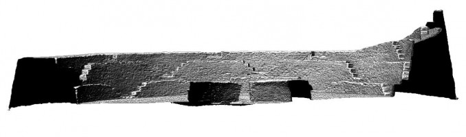
| Name | Front elevation section view of Cahergal Stone Fort, Kerry |
| Description | Front elevation section view of Cahergal Stone Fort, Kerry |
| Type | Image |
| Format | image/jpeg |
| Copyrights |
|
| Link |
 |
| Landing Page |
|
| Metadata | Information |
| Thumbnail |

|
| Name | Perspective view 4 of Cahergal Stone Fort, Kerry |
| Description | Perspective view 4 of Cahergal Stone Fort, Kerry |
| Type | Image |
| Format | image/jpeg |
| Copyrights |
|
| Link |
 |
| Landing Page |
|
| Metadata | Information |
| Thumbnail |

|
| Name | Perspective view 3 of Staigue Fort, Kerry |
| Description | Perspective view 3 of Staigue Fort, Kerry |
| Type | Image |
| Format | image/jpeg |
| Copyrights |
|
| Link |
 |
| Landing Page |
|
| Metadata | Information |
| Thumbnail |

|
| Name | Perspective view 2 of Cahergal Stone Fort, Kerry |
| Description | Perspective view 2 of Cahergal Stone Fort, Kerry |
| Type | Image |
| Format | image/jpeg |
| Copyrights |
|
| Link |
 |
| Landing Page |
|
| Metadata | Information |
| Thumbnail |

|
| Name | Perspective view 1 of Cahergal Stone Fort, Kerry |
| Description | Perspective view 1 of Cahergal Stone Fort, Kerry |
| Type | Image |
| Format | image/jpeg |
| Copyrights |
|
| Link |
 |
| Landing Page |
|
| Metadata | Information |
| Thumbnail |

|
| Name | Front elevation view of Cahergal Stone Fort, Kerry |
| Description | Front elevation view of Cahergal Stone Fort, Kerry |
| Type | Image |
| Format | image/jpeg |
| Copyrights |
|
| Link |
 |
| Landing Page |
|
| Metadata | Information |
| Thumbnail |

|
| Name | Right side elevation view of Cahergal Stone Fort, Kerry |
| Description | Right side elevation view of Cahergal Stone Fort, Kerry |
| Type | Image |
| Format | image/jpeg |
| Copyrights |
|
| Link |
 |
| Landing Page |
|
| Metadata | Information |
| Thumbnail |

|
| Name | Right side elevation section view of Cahergal Stone Fort, Kerry |
| Description | Right side elevation section view of Cahergal Stone Fort, Kerry |
| Type | Image |
| Format | image/jpeg |
| Copyrights |
|
| Link |
 |
| Landing Page |
|
| Metadata | Information |
| Thumbnail |

|
| Name | Left side elevation section view of Cahergal Stone Fort, Kerry |
| Description | Left side elevation section view of Cahergal Stone Fort, Kerry |
| Type | Image |
| Format | image/jpeg |
| Copyrights |
|
| Link |
 |
| Landing Page |
|
| Metadata | Information |
| Thumbnail |

|
| Name | Left side elevation view of Cahergal Stone Fort, Kerry |
| Description | Left side elevation view of Cahergal Stone Fort, Kerry |
| Type | Image |
| Format | image/jpeg |
| Copyrights |
|
| Link |
 |
| Landing Page |
|
| Metadata | Information |
| Thumbnail |

|
| Name | Rear elevation view of Cahergal Stone Fort, Kerry |
| Description | Rear elevation view of Cahergal Stone Fort, Kerry |
| Type | Image |
| Format | image/jpeg |
| Copyrights |
|
| Link |
 |
| Landing Page |
|
| Metadata | Information |
| Thumbnail |

|
| Name | Rear elevation section view of Cahergal Stone Fort, Kerry |
| Description | Rear elevation section view of Cahergal Stone Fort, Kerry |
| Type | Image |
| Format | image/jpeg |
| Copyrights |
|
| Link |
 |
| Landing Page |
|
| Metadata | Information |
| Thumbnail |

|
| Name | Plan view of Cahergal Stone Fort, Kerry |
| Description | Plan view of Cahergal Stone Fort, Kerry |
| Type | Image |
| Format | image/jpeg |
| Copyrights |
|
| Link |
 |
| Landing Page |
|
| Metadata | Information |
| Thumbnail |

|
| Name | External photo of Cahergal Stone Fort entrance, Kerry |
| Description | External photo of Cahergal Stone Fort entrance, Kerry |
| Type | Image |
| Format | image/jpeg |
| Copyrights |
|
| Link |
 |
| Landing Page |
|
| Metadata | Information |
| Thumbnail |

|
| Name | Internal photo of Cahergal Stone Fort, Kerry |
| Description | Internal photo of Cahergal Stone Fort, Kerry |
| Type | Image |
| Format | image/jpeg |
| Copyrights |
|
| Link |
 |
| Landing Page |
|
| Metadata | Information |
| Thumbnail |

|
| Name | External photo of Cahergal Stone Fort, Kerry |
| Description | External photo of Cahergal Stone Fort, Kerry |
| Type | Image |
| Format | image/jpeg |
| Copyrights |
|
| Link |
 |
| Landing Page |
|
| Metadata | Information |
| Thumbnail |

|
| Name | Plan section view of Cahergal Stone Fort, Kerry |
| Description | Plan section view of Cahergal Stone Fort, Kerry |
| Type | Image |
| Format | image/jpeg |
| Copyrights |
|
| Link |
 |
| Landing Page |
|
| Metadata | Information |
| Thumbnail |

|
| Name | Internal photo 2 of Cahergal Stone Fort entrance, Kerry |
| Description | Internal photo 2 of Cahergal Stone Fort entrance, Kerry |
| Type | Image |
| Format | image/jpeg |
| Copyrights |
|
| Link |
 |
| Landing Page |
|
| Metadata | Information |
| Name | Phase-based Terrestrial Laser Scanning |
| Description | Phase based terrestrial laser scanning using a Faro Focus 120 laser scanner. The instrument quotes the following specification: Distance accuracy up to ±2mm. Range from 0.6m up to 120m. Measurement rate up to 976,000 points/sec. Intensity & RGB. Integrated colour camera. Photorealistic 3D colour scans with up to 70 megapixels. Parallax-free colour overlay. |
| Purpose | Measured survey |
| Techinques | Georeferenced using RTK GPS with VRSnow corrections,Phased based terrestrial laser scanning |
| Equipment | Trimble 5800 RTK GPS,Faro Focus 3D 120 |
| Actor | Gary Devlin, Individual, Geo-surveyor |
| Actor | Robert Shaw, Individual, Senior Geo-surveyor |