Poulnabrone Portal Tomb (Turntable Movie)
CL009-034001-
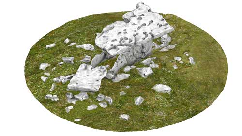
Megalthic portal tomb (dolmen) situated in the karst landscape of the Burren, County Clare. The tomb consists of a single large capstone that rests on two portal stones and two orthostats, and is situtated on a central oval cairns approximately 7m in diameter. A second large limestone slab; now positioned at the base of the tomb, could have originally be positioned beneath the main slab, and subsequently collapsed to its current location.
The site was excavated during 1986-88 revealing the remains of at least 36 individuals, and many artefacts including:bone, antler, chert flint and other stone items. Dating of the site places it in use from 3,800 - 3,600 BC.
|
Metadata
|
Information
|
|
Source
|
The Discovery Programme |
|
Contacts
|
Mr Anthony Corns
Technology Manager
The Discovery Programme
63
Merrion Square
Dublin
D2
Dublin
Dublin
Ireland
+353 1 639 3039
+353 1 639 3710
info@discoveryprogramme.ie
The Discovery Programme
|
|
Copyright Credit Line
|
Copyright © The Discovery Programme, All Rights Reserved. |
|
Europeana Rights
|
Creative Commons - Attribution, Non-Commercial, No Derivatives (BY-NC-ND) |
|
Spatial
|
Poulnabrone, Co. Clare
Poll na Brón
http://www.logainm.ie/5827.aspx
County Clare
Ireland
|
|
Protection Type
|
National Monuments in State Care |
|
Start Date
|
-4000 |
|
End Date
|
-2500 |
|
Period Name
|
Neolithic Period |
|
Materials
|
Stone |
|
Heritage Asset Type
|
Megalithic tomb - passage tomb |
|
Metadata
|
Information
|
|
Thumbnail
|

|
|
Name
|
Turntable video of the textured 3D model of Poulnabrone Portal Tomb, Co. Clare |
|
Description
|
Turntable video of the textured 3D model of Poulnabrone Portal Tomb, Co. Clare |
|
Type
|
Movie |
|
Format
|
mov |
|
Copyrights
|
Copyright ©The Discovery Programme
Creative Commons - Attribution, Non-Commercial, No Derivatives (BY-NC-ND)
|
|
Link
|
 |
|
Landing Page
|
 |
|
Metadata
|
Information
|
|
Name
|
Phase-based Terrestrial Laser Scanning |
|
Description
|
Phase based terrestrial laser scanning using a Faro Focus 120 laser scanner.
The instrument quotes the following specification: Distance accuracy up to ±2mm. Range from 0.6m up to 120m. Measurement rate up to 976,000 points/sec. Intensity & RGB. Integrated colour camera. Photorealistic 3D colour scans with up to 70 megapixels. Parallax-free colour overlay. |
|
Purpose
|
Measured survey |
|
Techinques
|
Georeferenced using RTK GPS with VRSnow corrections,Phased based terrestrial laser scanning |
|
Equipment
|
Trimble 5800 RTK GPS,Faro Focus 3D 120 |
|
Actor
|
Gary Devlin, Individual, Geo-surveyor |
|
Actor
|
Robert Shaw, Individual, Senior Geo-surveyor |