Church Bastion, Derry City Walls (High resolution 3D point cloud model)
LDY014:033
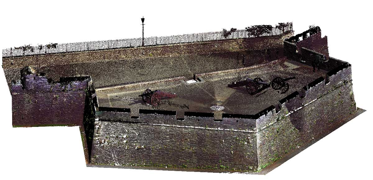
It was from Church Bastion that King James II was fired upon as he approached the city on April 18th 1689, when the siege began in earnest. In the bastion you can see two demi-culverin cannon. Along the outer wall face is a small gateway, known as a ‘sallyport’. Tradition has it that this gateway was used during the siege, and that it leads into St Columb’s Cathedral.
Derry~Londonderry: A guide to the historic city walls, Northern Ireland Environment Agency
|
Metadata
|
Information
|
|
Source
|
The Discovery Programme |
|
Contacts
|
Mr Anthony Corns
Technology Manager
The Discovery Programme
63
Merrion Square
Dublin
D2
Dublin
Dublin
Ireland
+353 1 639 3039
+353 1 639 3710
info@discoveryprogramme.ie
The Discovery Programme
|
|
Copyright Credit Line
|
Copyright © The Discovery Programme |
|
Europeana Rights
|
Paid access_no re_use |
|
Spatial
|
Church Bastion, Derry City Walls
|
|
Protection Type
|
National Monuments in State Care Northern Ireland |
|
Start Date
|
1601 |
|
End Date
|
1700 |
|
Period Name
|
17th Century AD |
|
Period Name
|
Post Medieval Period |
|
Materials
|
Schist, Sandstone, Stone |
|
Heritage Asset Type
|
Bastion |
|
Metadata
|
Information
|
|
Thumbnail
|

|
|
Name
|
High resolution 3D point cloud model of Church Bastion, Derry City Walls |
|
Description
|
High resolution 3D point cloud model of Church Bastion, Derry City Walls |
|
Type
|
3D |
|
Format
|
xyz |
|
Copyrights
|
Copyright © The Discovery Programme
Paid access_no re_use
|
|
Link
|
 |
|
Landing Page
|
 |
|
Metadata
|
Information
|
|
Name
|
Phase-based Terrestrial Laser Scanning |
|
Description
|
Phase based terrestrial laser scanning using a Faro Focus 120 laser scanner.
The instrument quotes the following specification: Distance accuracy up to ±2mm. Range from 0.6m up to 120m. Measurement rate up to 976,000 points/sec. Intensity & RGB. Integrated colour camera. Photorealistic 3D colour scans with up to 70 megapixels. Parallax-free colour overlay. |
|
Purpose
|
Measured survey |
|
Techinques
|
Georeferenced using RTK GPS with VRSnow corrections,Phased based terrestrial laser scanning |
|
Equipment
|
Trimble 5800 RTK GPS,Faro Focus 3D 120 |
|
Actor
|
Gary Devlin, Individual, Geo-surveyor |
|
Actor
|
Robert Shaw, Individual, Senior Geo-surveyor |