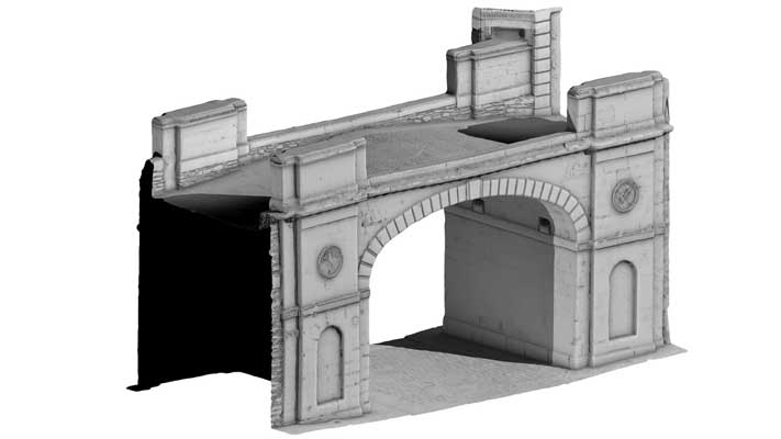
Ship Quay Gate, Derry City Walls (Turntable Movie)
LDY014:033
This was one of the four original gates into the 17th-century city, although the structure we see here today was built in 1805. The River Foyle originally flowed up to the foot of the city walls here and ships that entered Lough Foyle moored close by for people and goods to be unloaded.
The present structure was built in the first decade of the nineteenth century of ashlar sandstone and has a single elliptical-arched opening
Derry~Londonderry: A guide to the historic city walls, Northern Ireland Environment Agency
|
Metadata
|
Information
|
|
Source
|
The Discovery Programme |
|
Contacts
|
Mr Anthony Corns
Technology Manager
The Discovery Programme
63
Merrion Square
Dublin
D2
Dublin
Dublin
Ireland
+353 1 639 3039
+353 1 639 3710
info@discoveryprogramme.ie
The Discovery Programme
|
|
Copyright Credit Line
|
Copyright © The Discovery Programme |
|
Europeana Rights
|
Creative Commons - Attribution, Non-Commercial, No Derivatives (BY-NC-ND) |
|
Spatial
|
Shipquay Gate, Derry City Walls
http://www.logainm.ie/58666.aspx
County Derry
Northern Ireland
|
|
Protection Type
|
National Monuments in State Care Northern Ireland |
|
Start Date
|
1801 |
|
End Date
|
1900 |
|
Period Name
|
19th Century AD |
|
Period Name
|
Post Medieval Period |
|
Materials
|
Sandstone, Stone |
|
Heritage Asset Type
|
Gateway |
|
Metadata
|
Information
|
|
Thumbnail
|

|
|
Name
|
Turntable video of Shipquay Gate, Derry City Walls |
|
Description
|
Turntable video of Shipquay Gate, Derry City Walls |
|
Type
|
Movie |
|
Format
|
mov |
|
Copyrights
|
Copyright ©The Discovery Programme
Creative Commons - Attribution, Non-Commercial, No Derivatives (BY-NC-ND)
|
|
Link
|
 |
|
Landing Page
|
 |
|
Metadata
|
Information
|
|
Name
|
Phase-based Terrestrial Laser Scanning |
|
Description
|
Phase based terrestrial laser scanning using a Faro Focus 120 laser scanner.
The instrument quotes the following specification: Distance accuracy up to ±2mm. Range from 0.6m up to 120m. Measurement rate up to 976,000 points/sec. Intensity & RGB. Integrated colour camera. Photorealistic 3D colour scans with up to 70 megapixels. Parallax-free colour overlay. |
|
Purpose
|
Measured survey |
|
Techinques
|
Georeferenced using RTK GPS with VRSnow corrections,Phased based terrestrial laser scanning |
|
Equipment
|
Trimble 5800 RTK GPS,Faro Focus 3D 120 |
|
Actor
|
Gary Devlin, Individual, Geo-surveyor |
|
Actor
|
Robert Shaw, Individual, Senior Geo-surveyor |