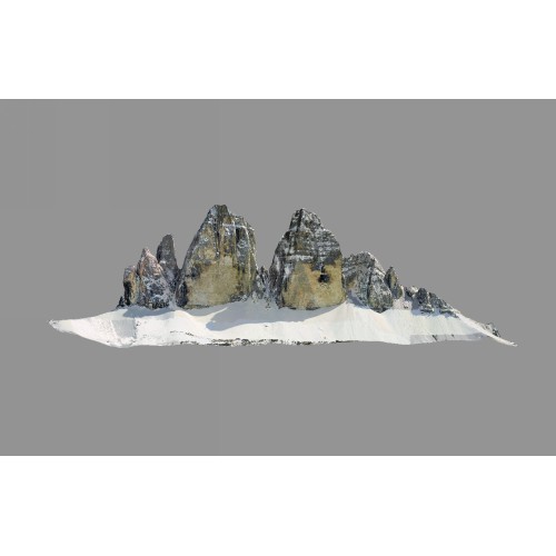
Tre Cime di Lavaredo - 3D
The Tre Cime di Lavaredo (Italian for "the three peaks of Lavaredo"), also called the Drei Zinnen in German, are three famous peaks in the Sexten Dolomites of northeastern Italy. They are probably one of the best-known mountain groups in the Alps. The three peaks are, from east to west: Cima Piccola (little peak, 2857 metres), Cima Grande (big peak, 2999 metres) and Cima Ovest (western peak, 2973 metres).
The peaks are composed of dolostones, as are many other groups in the Dolomites. They lie on the border between the Italian provinces of South Tyrol and Belluno.
|
Metadata
|
Information
|
|
Source
|
FBK - Fondazione Bruno Kessler |
|
Contacts
|
Fabio RemondinoFBK - Fondazione Bruno KesslerUnità di ricerca 3D Optical Metrology (3DOM)
http://3dom.fbk.eu/en/home3D Optical Metrology (3DOM) Unit
http://3dom.fbk.eu/en/home |
|
Copyright Credit Line
|
Università degli studi di Pavia. Helica. Codevintec Italiana. Gexcel. Protocube. 3D-ICONS. FBK-3DOM |
|
Europeana Rights
|
Creative Commons - Attribution, Non-Commercial, No Derivatives (BY-NC-ND) |
|
Start Date
|
298.9 ± 0.2 million years ago |
|
End Date
|
252.2 ± 0.5 million years ago |
|
Period Name
|
Permian geologic period |
|
Materials
|
Dolostones |
|
Heritage Asset Type
|
Mountain peaks |
|
Metadata
|
Information
|
|
Thumbnail
|

|
|
Name
|
Tre Cime di Lavaredo - 3D model LowRes |
|
Description
|
Low resolution 3D polygonal model with external texture for education and general public.
Number of triangles: 500000.
Mesh spatial resolution: 3.2m. |
|
Type
|
3D |
|
Format
|
OBJ |
|
Landing Page
|
 |
|
Metadata
|
Information
|
|
Thumbnail
|
|
|
Name
|
Tre Cime di Lavaredo - 3D model HighRes |
|
Description
|
High resolution 3D polygonal model with external texture for researches.
Number of triangles: 1510000.
Mesh spatial resolution: 1.9m. |
|
Type
|
3D |
|
Format
|
OBJ |
|
Landing Page
|
|
|
Metadata
|
Information
|
|
Name
|
Modelling and digitization process - Tre Cime di Lavaredo HighRes |
|
Description
|
In-house developed algorithms and combined with commercial packages were used to generate a dense point cloud. The obtained dense point cloud was triangulated to derive a mesh model and finally a high resolution texture was generated. |
|
Purpose
|
For research |
|
Metadata
|
Information
|
|
Name
|
Modelling and digitization process - Tre Cime di Lavaredo LowRes |
|
Description
|
Reduction of high resolution model in two lower resolutions |
|
Purpose
|
For education and general public |
|
Metadata
|
Information
|
|
Name
|
Metric survey - Tre Cime di Lavaredo |
|
Description
|
Combination of photogrammetric aerial and terrestrial, and terrestrial and airborne laser scanning surveys. |
|
Equipment
|
Optech ALTM 3100 EA LiDAR system,Wild RC30 Camera,Rollei digital camera,Optech ILRIS 3D,Lens 153 mm |