Archaeological site of Dromolaxia - Vizakia (Hala Sultan Tekke), snapshot
|
|
A Late Cypriot Bronze Age town is situated in a field west of the mosque of Hala Sultan Tekke and the Larnaca Salt Lake. The town extends about 600 x 400 m (240 000 sqm). A street, 4-5 m wide, runs through the town in a north to south direction. The house complexes often consist of a courtyard surrounded by rooms and in front of the entrances to the houses there is often a paved platform, raised above the level of the street like the passage ways of Pompeii. The houses were either used as workshops or for living and commercial activities. Three bathrooms with ashlar floors have been discovered. A large building with interior supports for pillars and an inner room may probably be identified as a sanctuary. The oldest remains of a settlement date back to the Middle Cypriote Bronze Age or c. 1600 B.C. The town was destroyed in c. 1190 B.C. and again in 1175 B.C and ceased to appear in the 11th century B.C. The site underwent a short revival in the Hellenistic period.
| Metadata | Information |
| Source | The Cyprus Institute - STARC |
| Europeana Rights |
|
| Heritage Asset Type | Archaeological area |
| Metadata | Information |
| Thumbnail |

|
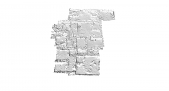
| Name | Archaeological site of Dromolaxia - Vizakia (Hala Sultan Tekke), Snapshot |
| Description | This is a snapshot taken from MeshLab. The image shows the result of the scanning session that took place at the Dromolaxia - Vizakia (Hala Sultan Tekke) excavation site (Building C) in 2011. |
| Type | Image |
| Link |
 |
| Landing Page |
|
| Metadata | Information |
| Name | Snapshots from 3D model |
| Description | Snapshots related to the 3D models from the excavation area of Dromolaxia - Vizakia (Hala Sultan Tekke) |