Image of the archaeological site of Dromolaxia - Vizakia (Hala Sultan Tekke), total station and Ground Penetrating Radar
|
|
|
Metadata
|
Information
|
|
Appellation
|
Image of the archaeological site of Dromolaxia - Vizakia (Hala Sultan Tekke), total station and Ground Penetrating Radar |
|
Address
|
Larnaca, Larnaca, Cyprus |
|
Coordinates (Lat, Lon)
|
(34.886370 , 33.604243)
Click to view it on Google Maps |
|
See it on Europeana
|
 |
|
Link
|
 |
|
Landing Page
|
 |
|
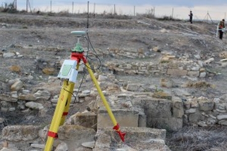
This image shows the archaeological site of Dromolaxia - Vizakia (Hala Sultan Tekke) in Larnaca. More specifically the picture shows the total station equipment along with the grids created for the geophysical survey. In addition, it depicts members of the STARC team using the Ground Penetrating Radar, RM15-D, RAMAC X3M with antennas and accessories during the geophysical survey that took place at the excavation site (Building C, Area 8) in January 2014. This geophysical technique is applicable to strata mapping in the cases of soils and rocks and depends on the different electrical properties that various materials have. G.P.R. can be used in a series of applications like the mapping of the bedrock depth, the determination of the stratum thickness and the aquifer depth, the location of physical and artificial cavities in the subsurface, cracks in the bedrock and the tracing of the changes in the rocks´ composition. The method is specially used in Archaeometry for the detection of buried antiquities. A high frequency electromagnetic radiation is transmitted in the ground (a pulse) and the reflected waves are recorded. The propagating electromagnetic energy in the ground depends on the subsoil´s electrical properties, the conductivity and the dielectric constant. Basically the method depends on the record of the waves reflected on surfaces that divide regions with different electrical properties. The time between the transmitting and the receiving pulse (signal) depends on the velocity along the trace the pulse followed. This time can be measured and if the electromagnetic wave propagation velocity is known then the depth of the reflector can be determined. In most of the geologic materials the conductivity and the dielectric constant (relative permittivity) are the main parameters that affect the pulse. Furthermore the absorption of the signal depends mainly on the antenna frequency, the conductivity and the dielectric constant. The Radar recordings (radiograms) are placed one beside the other so as to construct a section that simulates the real subsurface electrical section, producing information of the changes of the electrical properties with depth. The kit of the GPR includes the Integrated Radar Control Unit, a monitor that the data are stored as well, the special cart on four wheels and a second one with two wheels and also the different types of antennas (100,250,500MHz).
|
Metadata
|
Information
|
|
Source
|
The Cyprus Institute - STARC |
|
Europeana Rights
|
Free access_no re_use |
|
Heritage Asset Type
|
Archaeological area |
|
Metadata
|
Information
|
|
Thumbnail
|

|
|
Name
|
Image of the archaeological site of Dromolaxia - Vizakia (Hala Sultan Tekke), total station and Ground Penetrating Radar |
|
Description
|
This image shows the archaeological site of Dromolaxia - Vizakia (Hala Sultan Tekke) in Larnaca. More specifically the picture shows the total station equipment along with the grids created for the geophysical survey. In addition, it depicts members of the STARC team using the Ground Penetrating Radar, RM15-D, RAMAC X3M with antennas and accessories during the geophysical survey that took place at the excavation site (Building C, Area 8) in January 2014. This geophysical technique is applicable to strata mapping in the cases of soils and rocks and depends on the different electrical properties that various materials have. G.P.R. can be used in a series of applications like the mapping of the bedrock depth, the determination of the stratum thickness and the aquifer depth, the location of physical and artificial cavities in the subsurface, cracks in the bedrock and the tracing of the changes in the rocks´ composition. The method is specially used in Archaeometry for the detection of buried antiquities. A high frequency electromagnetic radiation is transmitted in the ground (a pulse) and the reflected waves are recorded. The propagating electromagnetic energy in the ground depends on the subsoil´s electrical properties, the conductivity and the dielectric constant. Basically the method depends on the record of the waves reflected on surfaces that divide regions with different electrical properties. The time between the transmitting and the receiving pulse (signal) depends on the velocity along the trace the pulse followed. This time can be measured and if the electromagnetic wave propagation velocity is known then the depth of the reflector can be determined. In most of the geologic materials the conductivity and the dielectric constant (relative permittivity) are the main parameters that affect the pulse. Furthermore the absorption of the signal depends mainly on the antenna frequency, the conductivity and the dielectric constant. The Radar recordings (radiograms) are placed one beside the other so as to construct a section that simulates the real subsurface electrical section, producing information of the changes of the electrical properties with depth. The kit of the GPR includes the Integrated Radar Control Unit, a monitor that the data are stored as well, the special cart on four wheels and a second one with two wheels and also the different types of antennas (100,250,500MHz). |
|
Type
|
Image |
|
Link
|
 |
|
Landing Page
|
|
|
Metadata
|
Information
|
|
Name
|
Photographic campaign, the archaeological site of Dromolaxia - Vizakia (Hala Sultan Tekke), Larnaca |
|
Description
|
Photographic campaign for the documentation of the excavation area of Dromolaxia - Vizakia (Hala Sultan Tekke), Larnaca |
